Western Cape Wildfires: Worst Season in a Decade Update 26 January 2026
January 26, 2026
Western Cape Wildfires: Worst Season in a Decade
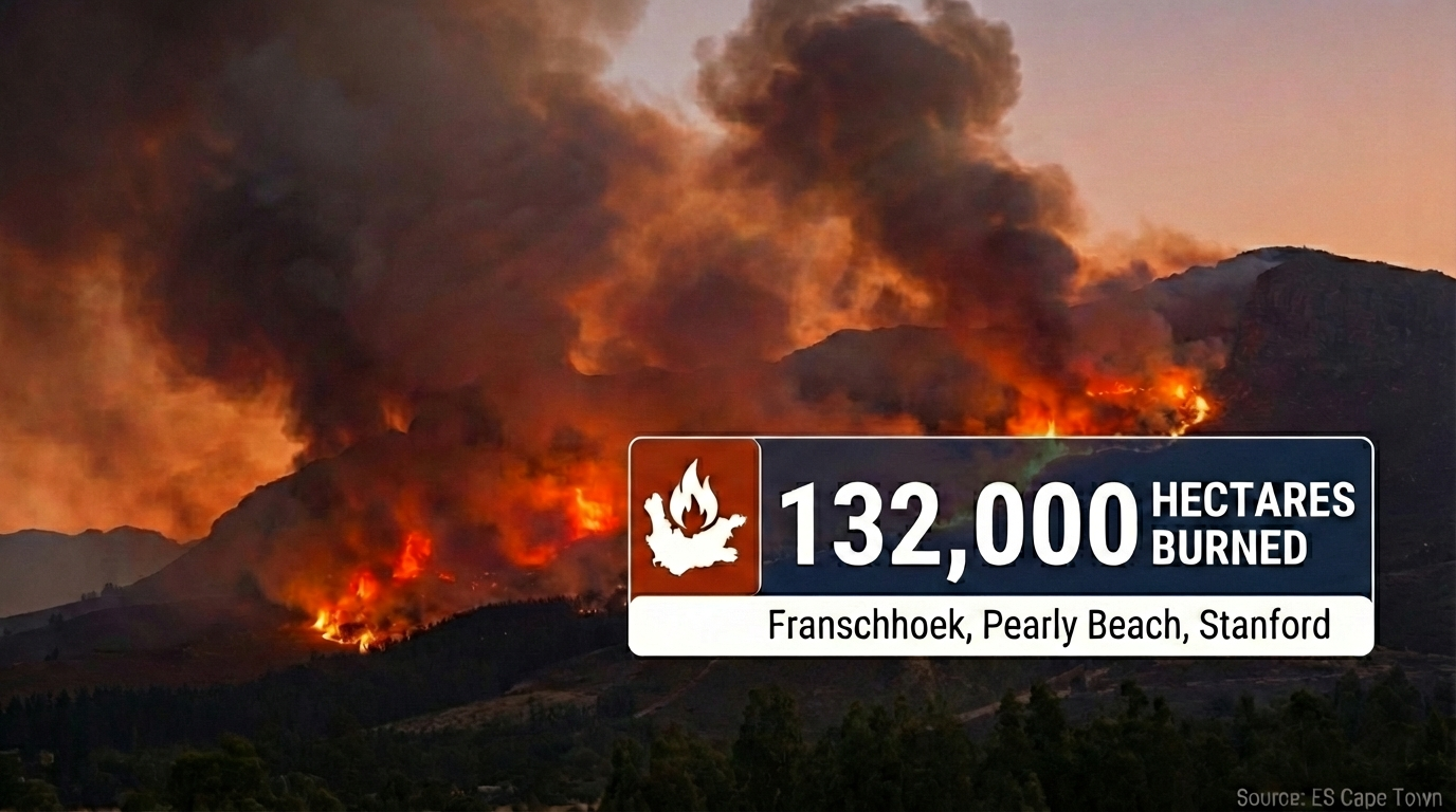
132,000 hectares burned province-wide as Cabinet requests disaster declaration. Franschhoek fire enters third week with active fire lines in Banghoek Valley. Fire season expected to extend through May 2026. Real-time tracking and safety guidance.
🔥 ONGOING — Franschhoek (Day 19+)
26 January: Teams still battling the blaze on mountains above Franschhoek. Fire lines at the top of Banghoek Valley remain active. Ground teams deployed Sunday afternoon to contain the fire as it moved into more accessible terrain. Aerial crews transporting teams from NCC, CapeNature and MTO Forestry. Terrain remains "extremely steep and dangerous" with no guarantee of success.
Franschhoek Pass: Reopened 23 January after earlier closure. One active fire line remains high in the mountains — no current threat to property.
Total burned (Franschhoek area): 23,500+ hectares since fires began 8 January. Teams focused on protecting the Banghoek Valley.
Executive Summary (26 January): The 2025/26 fire season is officially the worst since 2015. Provincial Cabinet has requested a disaster declaration from the National Disaster Management Centre. Between 1 Dec 2025 and 11 Jan 2026, over R19 million was spent on firefighting (R16m on aerial resources alone). Fire season is expected to extend through May 2026. No human fatalities reported — a testament to coordinated emergency response — but widespread structural damage and significant wildlife loss.
By the Numbers
Regional Status Updates
🔥 Franschhoek / Cape Winelands
Active — Day 19+⚠️ Pearly Beach (Overstrand)
Active Containment⚠️ Stanford (Overstrand)
Containment Ongoing🌲 Cederberg Wilderness
Monitoring / RestrictedProvincial Disaster Declaration
On 22 January, Premier Alan Winde confirmed that the provincial Cabinet has formally requested a disaster declaration from the National Disaster Management Centre (NDMC) under Section 23 of the Disaster Management Act.
ℹ️ What the disaster declaration enables
Access to emergency funding • Ability to move budgets between departments • Strengthened governance and coordinated response • Prioritization of firefighting operations, water infrastructure, and municipal support.
The declaration also covers water security challenges affecting several municipalities. Knysna Municipality has been hardest hit, with its primary dam at only 15% capacity and just 10 days of buffer supply remaining.
Why This Season Is Exceptional
Climate experts describe this fire season as the result of "a rare convergence of climatic conditions" that created, in the words of Stellenbosch University's Neville Sweijd, "all the right ingredients for an exceptional fire season."
Three critical factors:
1. Heavy fuel loads — Wet 2023/2024 seasons produced abundant vegetation growth, now dry and ready to burn.
2. Persistent strong winds — Gusts up to 50–80 km/h ground aerial resources and spread flames rapidly.
3. Expanding urban-wildland interface — More human activity near fire-prone areas increases ignition risk.
The aerial firefighting budget of R17 million for this season has been depleted. The province is making internal financial adjustments to keep the 21 aircraft operational, with final costs to be reconciled during the adjustment budget process.
Fire season is projected to extend through May 2026.
Travel Advisory (26 January)
| Location | Status | Advisory |
|---|---|---|
| Franschhoek mountains | Active | Pass open. Avoid mountain trails and hiking. Active fire line in Banghoek Valley. Smoke advisory may apply. |
| Pearly Beach | Caution | Active containment. Roads open but may close at short notice. Flare-up risk in dense vegetation. Verify conditions before travel. |
| Stanford | Caution | R43 open but conditions can change rapidly. Containment ongoing. Verify road status before departure. |
| Cederberg Wilderness | Restricted | CapeNature closure ended 26 Jan. Some properties remain closed. No climbing or bouldering in affected areas for potentially 6–12 months. Verify with CapeNature before visiting. |
| Signal Hill / Cape Town | Monitoring | Earlier fire activity contained. Check TMNP notices before hikes. Fire season runs Nov–May — closures can happen quickly. |
Safety Guidance & Emergency Contacts
⚠️ Early reporting saves lives and property
Do not assume "someone else has called it in." When reporting, provide: exact location, nearest landmark, what is burning, approximate size, direction of spread, wind direction, and immediate risks.
| Situation / Location | Contact |
|---|---|
| Life-threatening emergency (anywhere) | 112 (cellphone) |
| Cape Town metro | 107 (landline) or 021 480 7700 (cell) |
| Table Mountain National Park | 086 110 021 or 021 689 7438 (Newlands Fire Base) |
| Overstrand / Overberg | 028 425 1690 |
| Cape Winelands District | 021 887 4446 |
| West Coast District | 022 433 8700 |
| Garden Route / Eden | 044 805 5071 |
Live Monitoring Tools
Interactive Map
The map below shows key fire locations. Toggle the layer control (top right) to add satellite hotspot overlays from NASA Earthdata GIBS.
Sources & Verification
This update is based on verified reporting from:
- SABC News (26 Jan) — Firefighters still battling blaze above Franschhoek
- Western Cape Government (22 Jan) — Premier Winde briefing on wildfires and water security
- Time Out Cape Town — Franschhoek fires update (rolling)
- Overstrand Municipality — Official fire updates
- IQAir (22 Jan) — Pearly Beach and Stanford fire analysis
- Daily Maverick (18 Jan) — Inferno Madness: Cape's adverse weather
- Eyewitness News — Cederberg wildfire coverage
⚠️ Disclaimer
This update is for informational purposes and represents conditions as of 26 January 2026. Fire conditions change rapidly. Always verify current status with official authorities before making travel decisions. For active emergencies, call 112.
More in Annual & Seasonal Events
- New Developments: Western Cape Wildfires Update 22 January 2026
- Wildfires in Western Cape - What is the situation 19 January 2026?
- Western Cape Wildfires Update: 15 January 2026
- Why Is It Burning in Cape Town?
- Cape Town Cycle Tour 2026 (a.k.a. „Argus“): Visitor Guide to Riding the Cape Peninsula
- AfrikaBurn 2026: Building a Different Kind of Society in the Tankwa Desert
You May Also Like

New Developments: Western Cape Wildfires Update 22 January 2026
Photo courtesy of: SkyPixels, CC BY-SA 4.0, Wikimedia Commons Western Cape • 19–22 January 2026 • Franschhoek CRITICAL • Signal Hill • Strand / Helderberg…
Read Article
Wildfires in Western Cape - What is the situation 19 January 2026?
Photo courtesy of: Jeff Schmaltz, MODIS Land Rapid Response Team, NASA GSFC, Public domain, via Wikimedia Commons NEW UPDATE Newest compiled information is here: Read…
Read Article
Western Cape Wildfires Update: 15 January 2026
Photo courtesy of: SkyPixels, CC BY-SA 4.0, via Wikimedia Commons Cape Town • Western Cape • Summer wildfires • Peninsula + Winelands + Overberg Western…
Read Article
Why Is It Burning in Cape Town?
Photo courtesy of: Warren Rohner, CC BY-SA 2.0, via Wikimedia Commons Cape Town • Summer wildfires • Signal Hill, Table Mountain, the Cederberg Why Is…
Read Article
Cape Town Cycle Tour 2026 (a.k.a. „Argus“): Visitor Guide to Riding the Cape Peninsula
Photo: “Cape Town Cycle Tour 2024, cyclists on Chapman’s Peak” by Olga Ernst, CC BY-SA 4.0 , via Wikimedia Commons Cape Town • Road Cycling…
Read Article