46 maps of Cape Town
The collection maps food spots, hiking trails, tidal pools, transport routes and much else across the city, drawing on local knowledge.
Network charts
2These charts show who is connected to whom, drawn as a network instead of being plotted on a map.
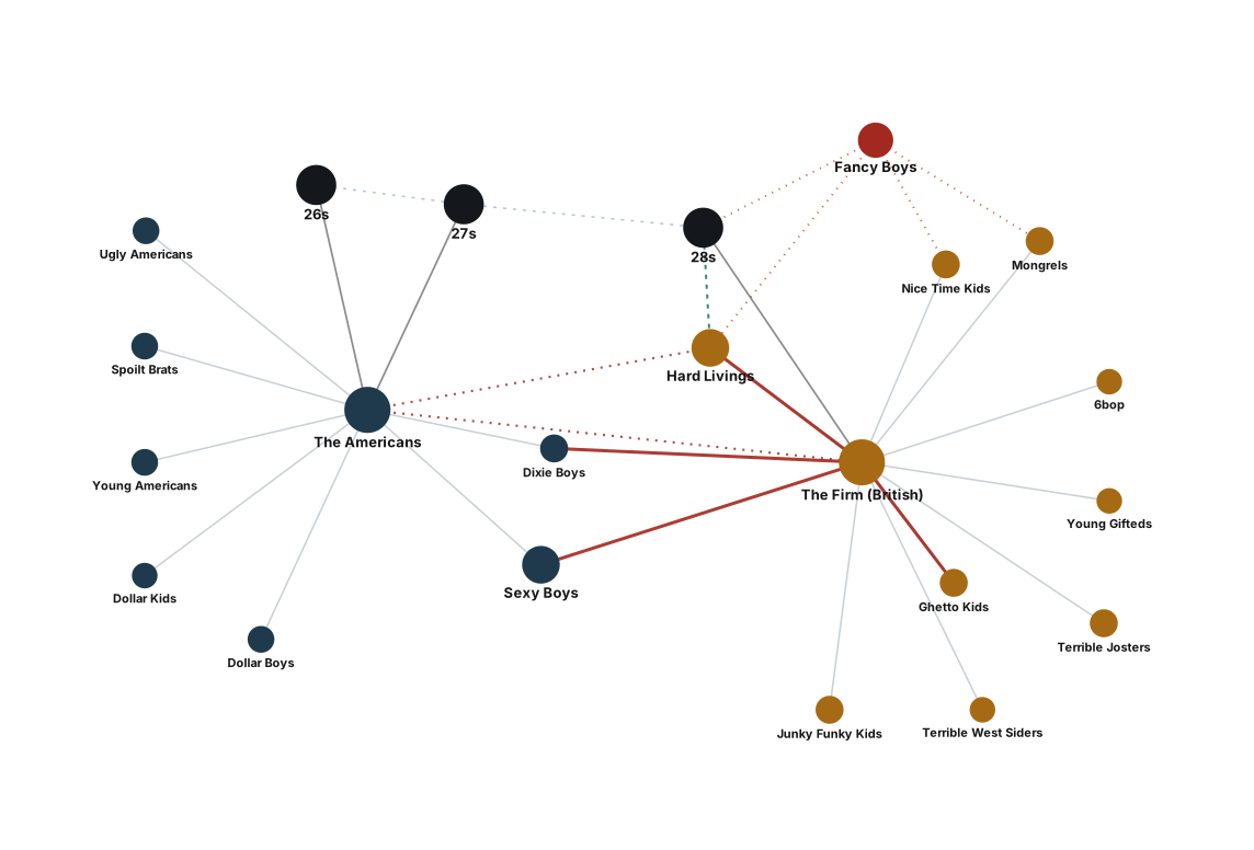
Cape Town's Gang Network
Twenty-two gangs and prison numbers are drawn with the alliances, splinters and rivalries that connect them.
Cape Town's Jazz Network
The chart links the players, venues and bands behind the city's jazz scene and shows who has shared a stage with whom.
Food & Dining
9Cape Town Food Map
The map marks street food, cafes and restaurants worth visiting across the city.
Sea Point Breakfast Guide
The guide maps the best breakfast and brunch spots in Sea Point.
Restaurant Map
Top-rated restaurants are plotted on the map by neighbourhood.
Markets Map 2026
The map shows the weekend and weekly markets across the Cape Town metro.
Restaurants with a View 2026
Nine restaurants with a view are mapped, from Camps Bay to Kalk Bay.
Oldest Wine Estates 2026
Eleven of the oldest wine estates near Cape Town are mapped, from Constantia to the Drakenstein valley.
Sea Point Breakfast Spots 2026
Ten breakfast and brunch spots in Sea Point are mapped, from Regent Road to Main Road.
Restaurant Scene 2026
The map tracks this year's notable openings, neighbourhood favourites and chef-driven restaurants, and it is kept up to date.
Wine Estates
Wine estates in Stellenbosch, Franschhoek and Constantia are mapped with their tastings, restaurants and views.
Outdoor & Adventure
10Hiking Trails
The map follows popular hiking routes on Table Mountain and the peninsula.
Crystal Pools
The map gives directions to the Crystal Pools trail in Gordons Bay and traces its route.
Tidal Pools Map
The map marks the natural tidal pools along the Cape Town coastline.
Tidal Pools Swimming 2026
Tidal pools suitable for swimming are shown with their safety ratings.
Hermanus
The map shows the whale-watching spots and other attractions in Hermanus.
Table Mountain
The map covers the trails, the cable car and the key viewpoints of Table Mountain.
Bioluminescence Beaches
The map marks the beaches where Cape Town's sea has been reported glowing at night.
Best Beaches
The map sets the Atlantic beaches beside those of False Bay and compares their wind exposure, water temperature and suitability for swimming.
Table Mountain Incident Map
The map shows the trailheads, the cableway and the 2026 incident sites on Table Mountain and Lion's Head.
Whale Watching Map 2026
The map marks the viewing spots for southern right whales from False Bay to the Whale Coast.
Crime & Safety
3Crime Map
Crime data is mapped ward by ward across the city.
Permit Scam Hotspots
The map marks the confirmed locations of the Cape Town permit and card-cloning scam, as given in news reports.
Mill Street Off-Ramp Hotspot Map
The map shows the Gardens Centre off-ramp where motorists have been ambushed, together with the reported incidents.
Transport
7Around the Cape: Live Ship Traffic
Ships rounding the Cape of Good Hope are replayed from their live AIS signals.
One Day Around the Cape
Twenty-four hours of shipping off South Africa were recorded and are replayed on the map.
MyCiTi Bus Routes
The map shows the MyCiTi public transport network and the locations of its stations.
MyCiTi Live Network
The live map shows the MyCiTi bus network with all its stops and routes.
Spatial Divide
The geographic and socio-economic divide of the city is drawn on the map.
Philip Kgosana Drive
The map follows the route of Philip Kgosana Drive and marks its landmarks.
Germany to Cape Town Flight Routes
The map shows the direct and one-stop routes from German airports to Cape Town, with prices and booking notes.
Accommodation
3Culture & Events
7Language Map
The map shows the dominant languages spoken across the suburbs of Cape Town.
Live Music Venues
The map marks the bars, clubs and venues that host live music regularly.
Lumenocity Map
The map shows the locations of the Lumenocity light festival and its walking route.
ULTRA Cape Town 2026
The map shows the venue of the ULTRA South Africa 2026 festival.
Cape Town Historic Sites Map
The map marks the ten most significant historical places in Cape Town from the VOC, colonial and modern eras, from the Company's Garden of 1652 to Robben Island.
Nelson Mandela Heritage Sites
The map traces Mandela's places in Cape Town and Paarl, from Robben Island to Victor Verster.
Wedding Venues Map
Nineteen reference wedding venues across Cape Town and the Winelands are mapped by budget tier.
General
7Autumn 2026 Events
Seasonal events, fires and dam levels for autumn 2026 are brought together on one map.
Power Stations
The map shows South Africa's major power stations.
Cape Town Schools
Public and private schools across the metro are mapped, which helps when choosing a neighbourhood by catchment area.
Things to Do: Zone Map
The map groups the best things to do in Cape Town zone by zone for a three-day visit.
Western Cape Data Centres 2026
The map shows the operational and planned data centres in the Western Cape, together with the landing points of the subsea cables.
Southern Suburbs Corridor
The map follows Rondebosch, Rosebank, Claremont and Woodstock along the southern line.
Where Semigrants Land
The map shows where people moving to the Western Cape settled in 2024 and 2025, from the metro to the Overberg.