Western Cape Wildfires Update: 15 January 2026
January 12, 2026

Photo courtesy of: SkyPixels, CC BY-SA 4.0, via Wikimedia Commons
Cape Town • Western Cape • Summer wildfires • Peninsula + Winelands + Overberg
Western Cape Wildfires Update: 15 January 2026
Summer is the Western Cape’s high-risk fire period: months of dry weather lower fuel moisture, and wind can push a small ignition into a fast-moving blaze. This update (15 Jan 2026, SAST) focuses on the locations most likely to affect visitors — Signal Hill and Table Mountain access in Cape Town, plus regional incidents in the Overberg (Pearly Beach / Stanford) and the Cape Winelands (Franschhoek / Wemmershoek area). You’ll also find a map with approximate locations and live satellite links for near real-time fire detections.
Executive summary: Recent reporting from provincial disaster management described the wildfire wave as largely under control after an intense week (at least 10 major blazes, nearly 90,000 hectares burned, and 45 structures damaged), but warned that volatile winds can still trigger flare-ups and renewed spread. For visitors, the most immediate travel variables are: (1) Overstrand updates (Pearly Beach reported as contained; Stanford operations continuing with controlled backburns), (2) Winelands impacts (Franschhoek-area burn footprint + property loss), and (3) official closure notices such as the Cederberg Wilderness Area cottages/trails closure window (13–26 Jan).
Before you hike or drive: check (1) SAWS Fire Danger Index, (2) park/trail/road status, (3) AFIS/FIRMS for active detections.
1) Latest developments this week (12–15 Jan)
Latest developments this week (12–15 Jan 2026)
Province: “largely under control” Wind still the spoiler Overstrand: Pearly Beach contained Stanford: controlled backburns R43 open (but can close) Winelands impact confirmed Cederberg closures posted
Province-wide (Western Cape): Officials said the province-wide fire situation is largely under control, but that volatile winds mean flare-ups can still escalate quickly — especially in mountain and fynbos terrain. In other words: “contained” doesn’t mean “finished,” and access restrictions can remain while mop-up continues.
Overstrand (Pearly Beach + Stanford): Reporting said the Pearly Beach blaze was contained, while crews in Stanford continued with controlled backburns to prevent spread. Government communication and municipal updates also indicated that the R43 corridor was open, while cautioning that roads can close at short notice if conditions change.
Cape Winelands (Franschhoek): Reporting described the Franschhoek-area fire as having burned roughly 17,000 hectares and destroyed two properties — a reminder that hiking and reserve access can shift quickly even after the most dramatic fire behaviour subsides.
Cederberg (travel access): CapeNature posted an alert that all cottages (Algeria & Bosherberge) and hiking trails at Cederberg Wilderness Area would be closed from 13–26 Jan 2026. If you’re planning a Cederberg trip, treat that closure window as a hard constraint.
Travel logic for this week: plan “open vs closed” first, then smoke/wind second. If a corridor or reserve is open in the morning, still re-check before you drive — wind shifts are when plans get rewritten.
2) What’s happening now (15 Jan)
Transparency note: This page is updated on 15 Jan, but the most recent confirmed incident reporting and official notices referenced below are dated 12–13 Jan (plus municipal notices around 11–12 Jan). If you’re travelling today, always verify with official channels before leaving.
Cape Town (Signal Hill): Early-January vegetation fire activity on Signal Hill was brought under control, but firefighting updates stressed ongoing hotspot/flare-up management during mop-up. The traveller takeaway: even after “under control” headlines, access restrictions and smoke can linger.
Overberg / Overstrand (Pearly Beach + Stanford): The travel-relevant headline for this week is improved containment: Pearly Beach reported as contained, with Stanford operations continuing via controlled backburns. Road access (including the R43) was communicated as open in updates, but with explicit warnings that short-notice closures can return if wind or visibility worsens.
Cape Winelands (Franschhoek / Wemmershoek): Winelands impacts were described as significant (burned area + property loss). Even when town areas look calm, reserve and mountain route access can be restricted temporarily for safety and mop-up operations.
Cederberg (regional): In addition to earlier mop-up reporting in the greater Cederberg area, CapeNature posted a specific closure notice for cottages and hiking trails at Cederberg Wilderness Area (13–26 Jan).
Travel framing: inside Cape Town, your decision is usually “is this hike open and is smoke/wind safe?” outside the city, it becomes “are roads/reserves open — and is the area still under mop-up patrols where conditions can flip?”
3) Why summer is higher risk: dry fuels + heat + wind + ignition
Fire risk rises after long dry spells: fuels lose moisture over weeks, making ignition easier. Wind is the multiplier — it can accelerate spread and carry embers that start spot fires ahead of the main front. Most visitor-facing impacts are operational: trail closures, restricted access, smoke, and detours.
Simple model: dry fuels + heat + wind + an ignition source. Summer increases the first three. That’s why prevention and situational awareness matter most in this season.
4) Cape Town reality: access changes fast in TMNP
Table Mountain National Park (TMNP) notes Cape Town’s high fire season runs from November to May. In practice, that means closures can happen quickly during dry, windy periods — and reopening can be phased or delayed for safety. Treat official closure notices as final: they exist to prevent hikers and drivers from being caught by changing wind and smoke.
5) Quick snapshot table (Cape Town + Winelands + Overberg)
| Where | Status (mid-Jan 2026 context) | Visitor impact (typical) |
|---|---|---|
| Signal Hill (Cape Town) | Fire brought under control; mop-up included hotspot / flare-up monitoring in early-Jan updates. | Short-notice restrictions and smoke impacts; avoid closed access points and ridgelines in wind. |
| Pearly Beach / R43 corridor (Overstrand) |
Reported as contained in 12 Jan reporting; municipal communication also indicated road access open at times (including R43) while warning closures may return at short notice.
Municipal estimate (11 Jan, 18:30): >33,000 ha burned (Pearly Beach). |
Even when roads are open, expect rapid changes. Confirm status before a coastal day trip. |
| Stanford (Overberg/Overstrand) |
Ongoing operations described with controlled backburns to prevent spread.
Municipal estimate (11 Jan, 18:30): >4,000 ha burned (Stanford). |
Rapid plan changes; smoke can affect outdoor activity and road visibility. |
| Franschhoek / Wemmershoek (Cape Winelands) | Reported this week: ~17,000 ha burned and two properties destroyed near Franschhoek. | Trail/reserve closures can appear suddenly even if town areas look calm; smoke can linger after containment. |
| Cederberg Wilderness Area (regional travel) | CapeNature alert: cottages and hiking trails closed 13–26 Jan 2026. Earlier reporting referenced mop-up operations after an extended blaze in the broader Cederberg region. | Do not plan cottages/overnight hikes during closure window; confirm access before entering the region. |
6) Map: recent wildfire locations
The map below marks recent incidents and provides direct links to satellite tools (AFIS, FIRMS, Worldview) so you can check active detections. Pins show approximate locations for orientation — not official perimeters.
7) A practical visitor checklist (hikes + drives)
A practical checklist for summer days
Fire Danger Index Wind Closures Smoke Road status (R43 etc.)
1) Check the SAWS Fire Danger Index. If danger is high/extreme, avoid exposed ridgelines and remote routes without clear exits.
2) Check trail and road status. Closures can change within hours — treat official notices as final.
3) Treat smoke as a real signal. If smoke is heavy, reduce exertion; if you have asthma, plan indoor alternatives.
4) If leaving Cape Town: confirm road corridors (especially coastal routes and the
R43)
before committing to a day trip.
If you plan to hike
If you’re driving out of the city
8) How to behave — and who to call if you spot smoke or flames
Summer in the Western Cape can be dry and windy. In those conditions, small mistakes can start fires and make them harder to control. Visitors don’t need specialised knowledge — they need consistent habits.
Behave like ignition is easy
Behave like access matters
If you spot smoke or a wildfire, report early. Early reports often make the difference between a short response and a long incident.
When you call, provide: (1) your exact location (drop a GPS pin if possible), (2) nearest landmark/trail/road, (3) what is burning (bush/trees/building), (4) approximate size and direction of spread (wind direction helps), and (5) any immediate risks (homes, hikers, powerlines).
| Where you are | Who to call | Use this when |
|---|---|---|
| Cape Town (City area) | 107 (landline) or 021 480 7700 (cellphone) | To report fires, smoke, flooding, rockfalls — or any urgent city emergency. |
| Table Mountain National Park (TMNP) | 086 110 021 (SANParks emergency) or 021 689 7438 (Newlands Fire Base) | To report fires or suspicious activity inside TMNP, including major hiking corridors. |
| Elsewhere in the Western Cape |
112 (cellphone national emergency) or call the closest district line Overberg: 028 425 1690 • West Coast: 022 433 8700 • Eden / Garden Route: 044 805 5071 Central Karoo: 023 414 2603 • Cape Winelands: 021 887 4446 |
If you are outside the metro area, or unsure which service has jurisdiction. Use district lines when you know your area. |
| If there is immediate danger | 112 (cellphone) | Life-threatening situations, evacuations, people trapped, fire in close proximity. |
Do not attempt to fight a wildfire. Move to a safe location first, then report. Keep roads clear and follow official instructions if evacuations or closures are issued.
9) Live tools + sources
Live / near real-time tools:
Incident reporting + official context (used for this 15 Jan update):
- Western Cape (province-wide: “largely under control” + wind risk + scale): https://www.ewn.co.za/2026/01/12/changing-winds-could-still-escalate-western-cape-fires-despite-recent-containment
- Western Cape costs + impact scale (~90,000 ha): https://www.ewn.co.za/2026/01/12/western-cape-incurs-more-costs-due-to-recent-fires
- Overstrand: Pearly Beach contained; Stanford controlled backburns: https://www.ewn.co.za/2026/01/12/overstrand-fires-pearly-beach-blaze-contained-stanford-crews-continue-with-controlled-backburns
- Overstrand roads open (R43) + “may close at short notice” (government comms): https://www.sanews.gov.za/south-africa/progress-made-containing-overstrand-fires
- Overstrand municipal estimate (Pearly Beach >33,000 ha; Stanford >4,000 ha @ 11 Jan 18:30): https://www.overstrand.gov.za/overstrand-fire-update-pearly-beach-stanford-fires-11-january-2026-1830/
- Signal Hill (contained; hotspot monitoring): https://www.ewn.co.za/2026/01/04/signal-hill-fire-under-control-but-firefighters-working-to-contain-hotspots
- Cape Winelands (Franschhoek ~17,000 ha; two properties destroyed): https://www.ewn.co.za/2026/01/13/cape-winelands-mayor-says-recent-fires-deeply-impacted-communities
- Cederberg Wilderness Area closure alert (13–26 Jan): https://www.capenature.co.za/reserves/
- Cederberg mop-up (context): https://www.ewn.co.za/2026/01/02/cederberg-wildfire-firefighters-begin-mopping-up-after-12-day-blaze
- TMNP fire season timing (Nov–May) + preparedness: https://www.sanparks.org/parks/table-mountain/fire-management
- TMNP reporting numbers (086 110 021 / 021 689 7438): https://www.sanparks.org/news/table-mountain-national-park-addresses-surge-in-fires
- Cape Town PECC emergency numbers (107 / 021 480 7700) PDF: https://resource.capetown.gov.za/documentcentre/Documents/Procedures%2C%20guidelines%20and%20regulations/About%20Public%20Emergency%20Communication.pdf
Disclaimer: This article is for general travel information, not emergency guidance. For active incidents, follow official instructions and local emergency services updates.
More in Annual & Seasonal Events
- Western Cape Wildfires: Worst Season in a Decade Update 26 January 2026
- New Developments: Western Cape Wildfires Update 22 January 2026
- Wildfires in Western Cape - What is the situation 19 January 2026?
- Why Is It Burning in Cape Town?
- Cape Town Cycle Tour 2026 (a.k.a. „Argus“): Visitor Guide to Riding the Cape Peninsula
- AfrikaBurn 2026: Building a Different Kind of Society in the Tankwa Desert
You May Also Like
Western Cape Wildfires: Worst Season in a Decade Update 26 January 2026
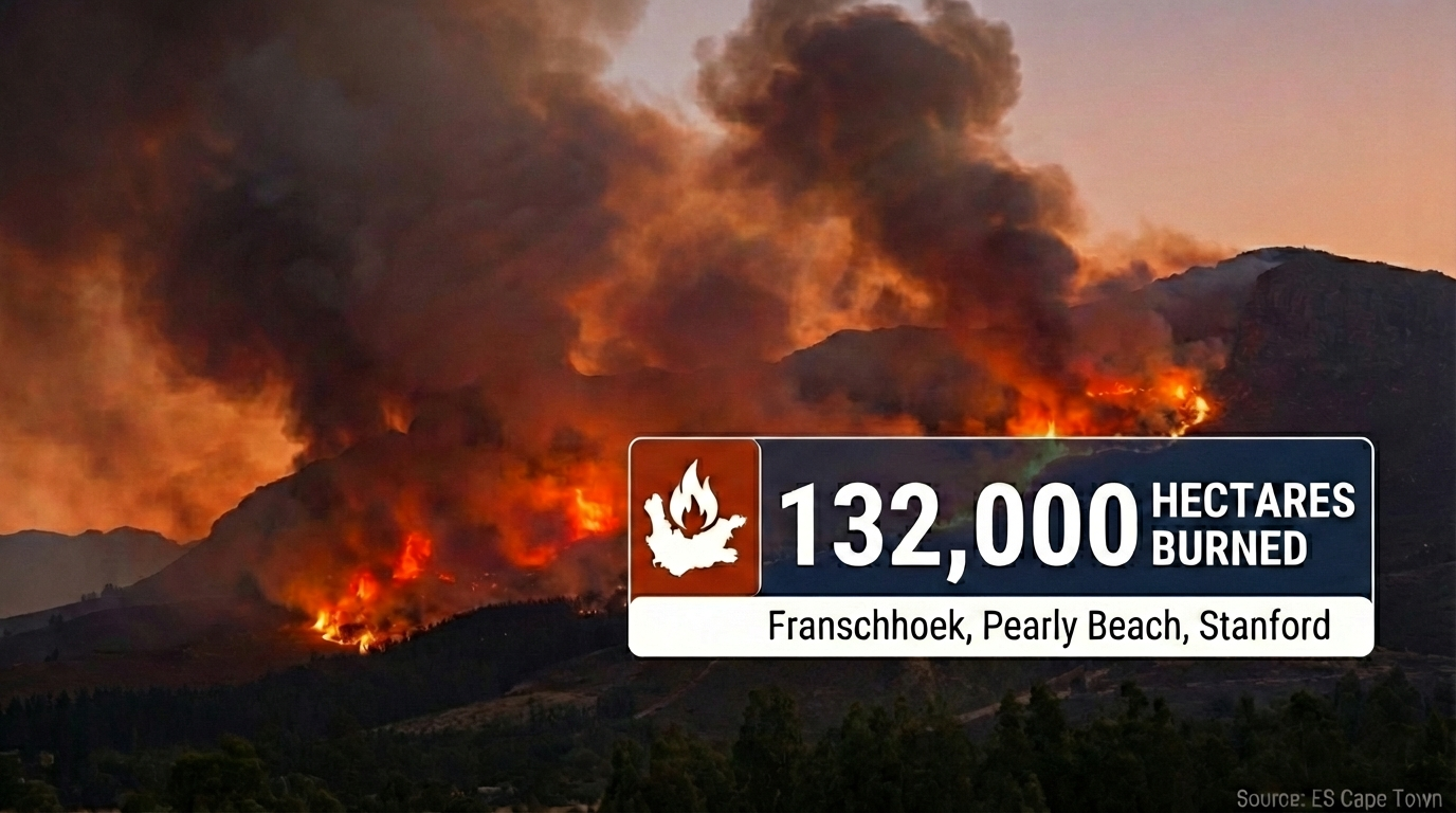
Live Update • 26 January 2026 Western Cape Wildfires: Worst Season in a Decade 132,000 hectares burned province-wide as Cabinet requests disaster declaration. Franschhoek fire…
Read Article
New Developments: Western Cape Wildfires Update 22 January 2026
Photo courtesy of: SkyPixels, CC BY-SA 4.0, Wikimedia Commons Western Cape • 19–22 January 2026 • Franschhoek CRITICAL • Signal Hill • Strand / Helderberg…
Read Article
Wildfires in Western Cape - What is the situation 19 January 2026?
Photo courtesy of: Jeff Schmaltz, MODIS Land Rapid Response Team, NASA GSFC, Public domain, via Wikimedia Commons NEW UPDATE Newest compiled information is here: Read…
Read Article
Why Is It Burning in Cape Town?
Photo courtesy of: Warren Rohner, CC BY-SA 2.0, via Wikimedia Commons Cape Town • Summer wildfires • Signal Hill, Table Mountain, the Cederberg Why Is…
Read Article
Cape Town Cycle Tour 2026 (a.k.a. „Argus“): Visitor Guide to Riding the Cape Peninsula
Photo: “Cape Town Cycle Tour 2024, cyclists on Chapman’s Peak” by Olga Ernst, CC BY-SA 4.0 , via Wikimedia Commons Cape Town • Road Cycling…
Read Article