Wildfires in Western Cape - What is the situation 19 January 2026?
January 19, 2026

Photo courtesy of: Jeff Schmaltz, MODIS Land Rapid Response Team, NASA GSFC, Public domain, via Wikimedia Commons
Newest compiled information is here:
Read the newest update (most current compiled report)
We’ve summarized the latest official notices and news.
Cape Town • Western Cape • Summer wildfires • Overstrand + Winelands + Cederberg
Wildfires in Western Cape — 19 January 2026 update
January has been a challenging month for the Western Cape, with significant vegetation fires affecting Pearly Beach and Stanford (Overstrand), the Franschhoek mountains (Winelands), and the Cederberg Wilderness Area. While the intense surge seen earlier this month has stabilized, conditions remain unpredictable. Some trail closures are still in effect, and sudden winds can quickly turn dormant hotspots into active flare-ups.
⚠️ Cape Town alert (18 Jan, ~22:00): Community-shared footage posted online shows a fire on Signal Hill. Please treat the area as high-risk until official updates confirm containment and access status.
What to do: avoid the slopes/viewpoints, keep clear of emergency routes, and follow official notices if access restrictions are issued.
Wind + smoke are your most reliable real-time warning signs.
Source: community post (video/footage)
Quick take (19 Jan): The province-wide wave still looks more stable than early January, with many incidents shifting into containment, mop-up, and monitoring — but the Signal Hill fire footage late on 18 Jan is a timely reminder that this is still peak season. Treat closure notices as non-negotiable (notably in the Cederberg), and approach Overstrand coastal day trips with extra care if fresh wind warnings appear.
Before you go anywhere outdoors: check (1) SAWS Fire Danger Index, (2) official road/trail notices, (3) AFIS/FIRMS detections (linked below).
1) Overall: more stable or more dangerous?
Overall, more stable — with local spikes still possible. Earlier reporting described the wider Western Cape situation as largely under control, while warning that shifting winds remain the big spoiler. Municipal updates from Overstrand earlier in the month showed why: even after progress, strong westerlies can still break containment and push an active edge toward new areas. On balance, the province is in a monitoring + mop-up phase in many places — but this is still peak season, so the risk hasn’t “gone away.”
How to read “stable” right now: stable means fewer large, fast-expanding fronts — not “everything is open.” Closures can remain while crews patrol lines, put out hotspots, and watch for wind-driven flare-ups.
Stable vs risky areas (practical read)
2) Places at a glance
These are travel-style signals (open vs caution vs closed) based on the latest published notices linked below. Always confirm the most recent official update before you go.
Cape Town — Signal Hill / TMNP
Pearly Beach — R43 corridor
Stanford — De Koude Vlakte area
Franschhoek / Wemmershoek
Cederberg Wilderness Area
Quick links (for today)
3) Please don’t be a “fire tourist”
Don’t drive out to watch fires. It’s not just risky — it can actively make the response harder. Sightseeing vehicles can clog narrow roads, block turnarounds, and slow down firefighting crews and emergency services. Smoke also reduces visibility and increases the chance of crashes, especially at night.
If you want to help: stay away, keep access routes clear, follow closures, and report new smoke/flames early via the numbers below. Share only verified official notices when it comes to closures — and never enter closed areas “for a better view.”
4) What’s happening by region (Cape Town • Overstrand • Winelands • Cederberg)
Cape Town (metro + TMNP)
Cape Town’s most prominent vegetation-fire reporting was earlier in January, with crews managing mop-up and hotspots after incidents were brought under control. The late-night Signal Hill fire footage on 18 Jan is a reminder that ignitions can happen fast in dry, windy conditions. Even when the metro looks “quiet,” Table Mountain National Park and surrounding mountain routes can still close quickly in peak season — so treat SANParks notices as the final word.
Overstrand / Overberg (Pearly Beach + Stanford)
Overstrand is still the most “watch this before you drive” area for visitors. Earlier municipal updates described strong westerly winds breaking containment in places and pushing fire edges, while other reporting described progress and containment phases. Practically: the corridor can look fine at breakfast and feel very different by mid-afternoon if wind shifts.
Winelands (Franschhoek / Wemmershoek)
The Winelands fires were described as deeply impactful earlier this month, with later reporting noting significant progress in containment — helped by weather shifts. The key for visitors is not “is the town open?” but “are mountain routes and reserve trails open today?” (those can change fastest).
Cederberg
For travellers, the Cederberg situation is simplest: there is a published closure window (cottages and hiking trails) through 26 January 2026. If you’re planning an overnight hike or cottages in the Cederberg Wilderness Area, you need an alternative plan inside that window.
5) What keeps risk high in summer (wind + dry fuels + ignition)
Two things make Western Cape fire weeks feel unpredictable: dry fuels (weeks of drying lowers moisture) and wind (spreads fire faster and carries embers). Add an ignition source — and what looks like “smoke far away” can turn into a road closure. If you want one daily signal to respect, it’s wind: strong wind is the day your plans should get more conservative.
6) Map: key locations mentioned
The map below marks key locations mentioned in this report. For a clearer wildfire “signal,” use the optional hotspot overlays (toggle in the layer control). These are map layers, not official perimeters — and they can also pick up non-fire heat sources.
7) Visitor checklist (hikes + day trips)
A practical checklist for summer days
Fire Danger Index Wind Closures Smoke Road status (R43 etc.)
1) Check the SAWS Fire Danger Index. If danger is high/extreme, avoid exposed ridgelines and remote routes without clear exits.
2) Check road + trail notices right before you go. Closures can change within hours — treat official notices as final.
3) Treat smoke as a real signal. If smoke is heavy, reduce exertion; if you have asthma, plan indoor alternatives.
4) For Overstrand day trips: confirm the
R43
and any local warnings before committing.
If you plan to hike
If you’re driving out of the city
8) Who to call if you spot smoke or flames
If you spot smoke or a wildfire, report early. Early reports often make the difference between a short response and a long incident.
When you call, provide: (1) your exact location (drop a GPS pin if possible), (2) nearest landmark/trail/road, (3) what is burning (bush/trees/building), (4) approximate size and direction of spread (wind direction helps), and (5) any immediate risks (homes, hikers, powerlines).
| Where you are | Who to call | Use this when |
|---|---|---|
| Cape Town (City area) | 107 (landline) or 021 480 7700 (cellphone) | To report fires, smoke, flooding, rockfalls — or any urgent city emergency. |
| Table Mountain National Park (TMNP) | 086 110 021 (SANParks emergency) or 021 689 7438 (Newlands Fire Base) | To report fires or suspicious activity inside TMNP, including major hiking corridors. |
| Elsewhere in the Western Cape |
112 (cellphone national emergency) or call the closest district line Overberg: 028 425 1690 • West Coast: 022 433 8700 • Eden / Garden Route: 044 805 5071 Central Karoo: 023 414 2603 • Cape Winelands: 021 887 4446 |
If you are outside the metro area, or unsure which service has jurisdiction. Use district lines when you know your area. |
| If there is immediate danger | 112 (cellphone) | Life-threatening situations, evacuations, people trapped, fire in close proximity. |
Do not attempt to fight a wildfire. Move to a safe location first, then report. Keep roads clear and follow official instructions if evacuations or closures are issued.
9) Live tools + sources
Live / near real-time tools:
Sources used for this 19 Jan overview (selected, travel-relevant):
- Signal Hill (video footage): https://www.reddit.com/r/capetown/comments/1qgj9s8/signal_hill_fire_18012026_10pm/
- Overstrand municipal update (15 Jan, 06:00) — wind shifts + rainfall notes: https://www.overstrand.gov.za/overstrand-fire-update-15-january-2026-0600/
- Overstrand municipal update (11 Jan, 18:30) — burn-area estimates: https://www.overstrand.gov.za/overstrand-fire-update-pearly-beach-stanford-fires-11-january-2026-1830/
- Western Cape: “largely under control” but winds could escalate (12 Jan): https://www.ewn.co.za/2026/01/12/changing-winds-could-still-escalate-western-cape-fires-despite-recent-containment
- Overstrand: Pearly Beach contained; Stanford controlled backburns (12 Jan): https://www.ewn.co.za/2026/01/12/overstrand-fires-pearly-beach-blaze-contained-stanford-crews-continue-with-controlled-backburns
- Winelands: mayor statement on impacts (13 Jan): https://www.ewn.co.za/2026/01/13/cape-winelands-mayor-says-recent-fires-deeply-impacted-communities
- Winelands: Wemmershoek progress update (15 Jan): https://www.sabcnews.com/sabcnews/significant-progress-in-containing-wemmershoek-fire/
- CapeNature closure notice — Cederberg Wilderness Area cottages + trails (13–26 Jan): https://www.capenature.co.za/reserves/cederberg-wilderness-area/
- TMNP fire management overview: https://www.sanparks.org/parks/table-mountain/fire-management
- SANParks emergency numbers (TMNP): https://www.sanparks.org/news/table-mountain-national-park-addresses-surge-in-fires
- Cape Town PECC emergency numbers PDF: https://resource.capetown.gov.za/documentcentre/Documents/Procedures%2C%20guidelines%20and%20regulations/About%20Public%20Emergency%20Communication.pdf
Disclaimer: This article is for general travel information, not emergency guidance. For active incidents, follow official instructions and local emergency services updates.
More in Annual & Seasonal Events
- Western Cape Wildfires: Worst Season in a Decade Update 26 January 2026
- New Developments: Western Cape Wildfires Update 22 January 2026
- Western Cape Wildfires Update: 15 January 2026
- Why Is It Burning in Cape Town?
- Cape Town Cycle Tour 2026 (a.k.a. „Argus“): Visitor Guide to Riding the Cape Peninsula
- AfrikaBurn 2026: Building a Different Kind of Society in the Tankwa Desert
You May Also Like
Western Cape Wildfires: Worst Season in a Decade Update 26 January 2026
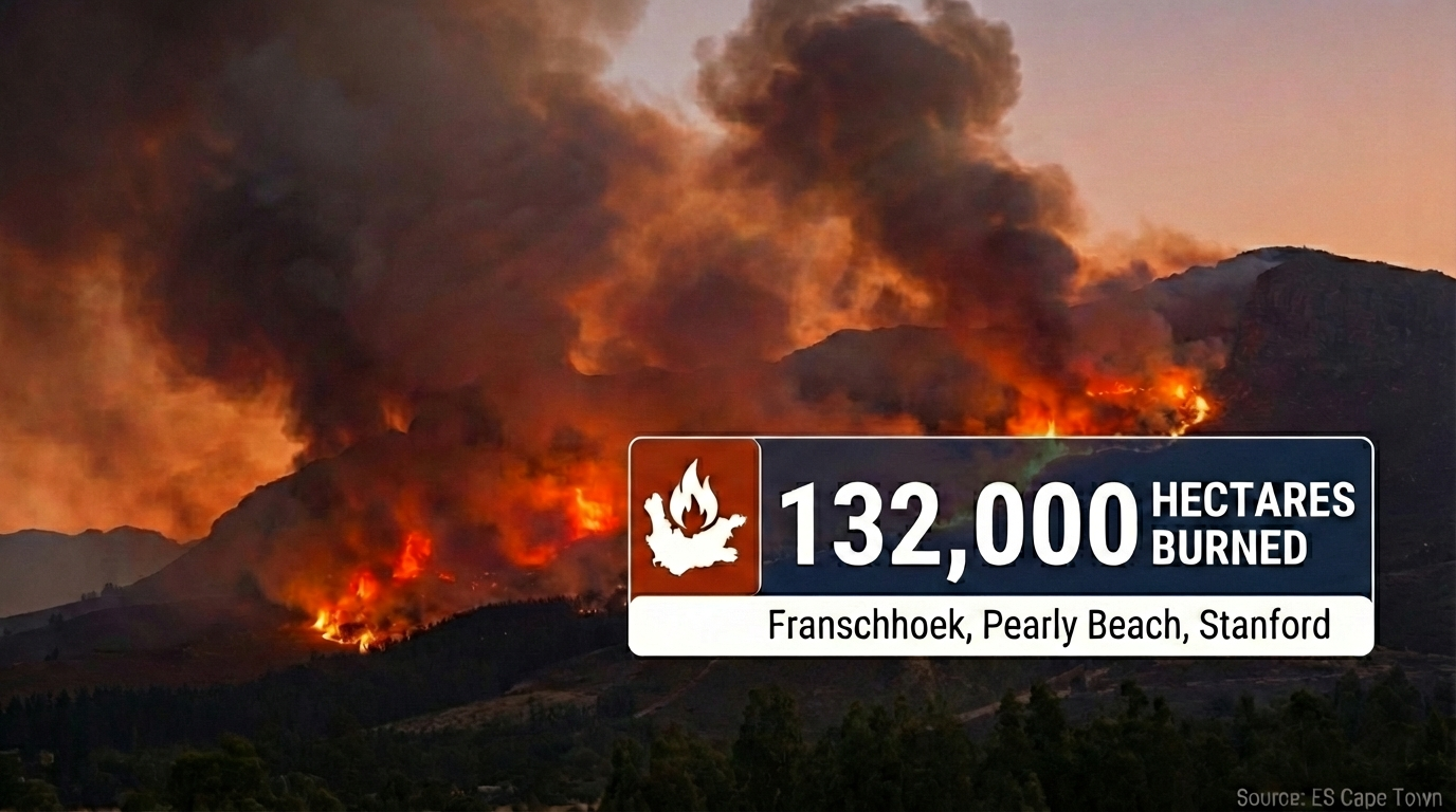
Live Update • 26 January 2026 Western Cape Wildfires: Worst Season in a Decade 132,000 hectares burned province-wide as Cabinet requests disaster declaration. Franschhoek fire…
Read Article
New Developments: Western Cape Wildfires Update 22 January 2026
Photo courtesy of: SkyPixels, CC BY-SA 4.0, Wikimedia Commons Western Cape • 19–22 January 2026 • Franschhoek CRITICAL • Signal Hill • Strand / Helderberg…
Read Article
Western Cape Wildfires Update: 15 January 2026
Photo courtesy of: SkyPixels, CC BY-SA 4.0, via Wikimedia Commons Cape Town • Western Cape • Summer wildfires • Peninsula + Winelands + Overberg Western…
Read Article
Why Is It Burning in Cape Town?
Photo courtesy of: Warren Rohner, CC BY-SA 2.0, via Wikimedia Commons Cape Town • Summer wildfires • Signal Hill, Table Mountain, the Cederberg Why Is…
Read Article
Cape Town Cycle Tour 2026 (a.k.a. „Argus“): Visitor Guide to Riding the Cape Peninsula
Photo: “Cape Town Cycle Tour 2024, cyclists on Chapman’s Peak” by Olga Ernst, CC BY-SA 4.0 , via Wikimedia Commons Cape Town • Road Cycling…
Read Article