New Developments: Western Cape Wildfires Update 22 January 2026
January 22, 2026

Photo courtesy of: SkyPixels, CC BY-SA 4.0, Wikimedia Commons
Western Cape • 19–22 January 2026 • Franschhoek CRITICAL • Signal Hill • Strand / Helderberg CAUTION • Overstrand
New Developments: Western Cape Wildfires Update 22 January 2026
Franschhoek fire enters day 5 and remains out of control as winds hamper aerial firefighting. Signal Hill reignited. A major industrial fire at Strand Foam (Broadlands Rd, Strand) was reported on 21 Jan, affecting the N2 / Sir Lowry’s Pass corridor. Province-wide: over 100,000 hectares burned. Real-time fire tracking and safety guidance for residents and visitors.
🔥 CRITICAL — Franschhoek (21 Jan): Fire has now burned for five consecutive days and remains out of control. The blaze crossed the Berg River overnight (19/20 Jan), moving onto the Stellenbosch side of the mountain. Multiple fire lines burning in inaccessible terrain. Helicopters unable to water-bomb due to winds reaching 50 km/h and severe air turbulence. Eucalyptus Forest engulfed. Equipment damaged during Tuesday night flare-ups.
Official statement (Jo-Anne Otto, Cape Winelands District): "It's very alarming when people say the fire is going towards Stellenbosch. It's not, it's still very far from Stellenbosch. However, it is on the Stellenbosch side of the Berg River."
DO NOT VISIT Franschhoek mountain areas. Heavy smoke advisory — residents told to stay indoors. No injuries or structural damage to homes reported so far, but conditions remain extremely dangerous.
Sources:
SABC News (21 Jan) •
VOC FM (20 Jan) •
eNCA (20 Jan)
Executive summary (22 Jan): The Western Cape wildfire situation has intensified significantly since our 19 January update. Franschhoek is now the province's most critical active incident — a five-day blaze burning out of control in rugged, inaccessible terrain. Signal Hill experienced renewed fire activity late on 18 January. Helderberg/Strand: a major industrial fire at Strand Foam was reported on 21 Jan, with heavy smoke visible from the N2 / Sir Lowry’s Pass approach. Overstrand (Pearly Beach/Stanford) remains in containment/monitoring phases but wind-driven flare-ups continue to threaten progress. Province-wide: over 100,000 hectares burned, nearly 7,000 people displaced, fire incidents up 5–16% compared to last year.
What changed since 19 Jan: Franschhoek fire crossed Berg River (major escalation), Signal Hill reignited, Strand Foam industrial fire reported in the Helderberg/Strand area (21 Jan), and wind conditions prevented aerial firefighting across multiple fronts.
What's happened: 19–22 January snapshot
🔴 Franschhoek (CRITICAL)
⚠️ Signal Hill (CAUTION)
⚠️ Strand / Helderberg (CAUTION)
⚠️ Pearly Beach (CAUTION)
⚠️ Stanford (CAUTION)
🚫 Cederberg (CLOSED)
📊 Province-wide
Regional deep dive
Franschhoek & Cape Winelands — The critical front
Day 5
Franschhoek fire duration (as of 21 Jan 2026)
The Franschhoek fire represents the most serious and challenging wildfire currently affecting the Western Cape. What began as a mountain slopes fire has evolved into a multi-front blaze burning in terrain so rugged that ground crews struggle to access it and weather conditions so severe that helicopters cannot fly.
Timeline of escalation:
19 Jan: Fire burning above Franschhoek in mountains; containment efforts showing progress; crews optimistic about weather window
20 Jan (overnight): Fire crossed the Berg River — a significant natural barrier — spreading onto the Stellenbosch side of the mountain. Wind speeds reached 50 km/h, preventing helicopter water-bombing operations. Fire entered area with recently cleared plantation, where dried stumps and uneven ground fueled rapid spread
21 Jan: Three fire lines burning in inaccessible terrain above Berg River Dam. Fourth fire line active between Cape Winelands and Overberg District boundaries. Eucalyptus Forest currently engulfed — highly flammable species creating intense fire behavior. Equipment damaged during sudden Tuesday night flare-up. Firefighters focused on property protection during overnight operations
What makes this fire so difficult:
Wind: Sustained winds up to 50 km/h create severe air turbulence that grounds helicopters.
Terrain: Rugged, mountainous landscape limits ground crew access.
Vegetation: Dense natural vegetation including Eucalyptus Forest plus cleared plantation stumps that act as concentrated fuel sources.
Weather: Hot conditions increase both fire intensity and risks to firefighters (dehydration, heat exhaustion).
Current status: OUT OF CONTROL. Cape Winelands District Municipality confirms fire remains uncontained. No injuries, loss of life, or structural damage to homes reported so far — but conditions remain extremely dangerous.
Visitor advisory — Franschhoek:
DO NOT VISIT mountain areas, hiking trails, or mountain passes. Heavy smoke advisory in effect — residents warned to stay indoors.
Expect road closures, detours, and severe smoke conditions.
Signal Hill & Cape Town metro
Late on 18 January (approximately 22:00 SAST), community-shared video footage showed renewed fire activity on Signal Hill, burning near Upper Strand Street close to High Level Road.
Why Signal Hill matters for context: the metro remains vulnerable in peak fire season — and closures can happen within hours during dry, windy conditions.
Visitor advisory — Cape Town / Signal Hill:
Avoid the area until official clearance. Check TMNP notices before ANY hike. If you see smoke or smell burning, report it and leave.
Helderberg / Strand — Strand Foam industrial fire (21 Jan)
On Wednesday 21 January, a major industrial fire was reported at Strand Foam (239 Broadlands Rd) in the Strand/Helderberg area. Public posts shared from the N2 / Sir Lowry’s Pass approach reported heavy smoke and a visible fire glow.
Why this matters for visitors: Industrial fires can generate thick, irritant smoke and severely reduce visibility on major corridors. If you're traveling the N2 or heading toward Strand / False Bay, treat the area as a dynamic smoke corridor and avoid driving toward smoke plumes.
Visitor advisory — Helderberg / Strand (N2 corridor):
Avoid driving “toward the smoke.” Check live conditions right before departing. If smoke is present: keep windows up, set A/C to recirculate, slow down if visibility drops, and reroute if needed.
Do not stop to watch the fire — keep routes clear for emergency services.
Strand Foam sources: CapeTownETC report • Reddit: Fire at Strand Foam • Reddit: Huge fire on the way into Cape Town
Overstrand — Pearly Beach & Stanford
The Overstrand fires (Pearly Beach and Stanford) remain active but in containment/monitoring phases.
Visitor advisory — Overstrand:
Exercise CAUTION. Check road status before traveling — conditions can change quickly with wind shifts. Avoid smoke corridors and do not “drive in to look.”
Why this season is exceptional — Expert analysis
Neville Sweijd, Executive Director of the School for Climate Studies at Stellenbosch University, describes this fire season as the result of "a rare convergence of climatic conditions" that has created what he calls "all the right ingredients for an exceptional fire season."
Three critical factors creating "exceptional" conditions
1. Heavy fuel loads (wet years → more vegetation → more fuel)
2. Persistent, strong winds (faster spread + spot fires + aircraft grounded)
3. Expanding urban-wildland interface (more ignition opportunities)
By the numbers — Impact assessment
100,000+
Hectares burned (province-wide)
6,999
People displaced (Oct 2025 – 9 Jan 2026)
5 days
Franschhoek fire duration (ongoing)
Travel advisory — What's safe, what's not (22 Jan)
| Location | Status | Advisory |
|---|---|---|
| Franschhoek mountains | OUT OF CONTROL | DO NOT VISIT mountain areas, trails, passes. Heavy smoke — stay indoors if possible. All mountain recreation closed. |
| Signal Hill / Cape Town metro | CAUTION | Avoid Signal Hill until clearance. Check TMNP notices before hikes. |
| Strand / Helderberg (incl. Strand Foam) | CAUTION | Industrial fire reported 21 Jan. Expect smoke/visibility risk near the N2 / Sir Lowry’s Pass corridor. Verify live conditions before travel. |
| Pearly Beach / Stanford | CAUTION | Check road status before travel. Conditions can shift rapidly with wind. Avoid smoke corridors. |
| Cederberg Wilderness | CLOSED | Cottages + trails closed through 26 January. Do not attempt access. |
Safety guidance & emergency contacts
Early reporting saves lives and property. Do not assume "someone else has called it in." Provide: exact location, nearest landmark, what is burning, approximate size, direction of spread, wind direction, and immediate risks.
| Location / Situation | Number to call | When to use |
|---|---|---|
| Life-threatening emergency (anywhere) | 112 (cellphone) | Fire in close proximity, evacuations, people trapped, immediate danger to life |
| Cape Town metro | 107 (landline) or 021 480 7700 (cellphone) | Fires, smoke, flooding, rockfalls, any urgent city emergency |
| Table Mountain National Park | 086 110 021 (SANParks emergency) or 021 689 7438 (Newlands Fire Base) |
Fires or emergencies inside TMNP boundaries (Signal Hill, hiking corridors, etc.) |
| Overstrand / Overberg | 028 425 1690 | Pearly Beach, Stanford, Hermanus, and surrounding areas |
| Cape Winelands District | 021 887 4446 | Franschhoek, Stellenbosch, Paarl, Worcester areas |
| West Coast District | 022 433 8700 | Cederberg, West Coast areas north of Cape Town |
| Garden Route / Eden | 044 805 5071 | Mossel Bay, George, Knysna, Plettenberg Bay areas |
Live monitoring tools & resources
Real-time fire detection & satellite monitoring:
🔥 AFIS Map Viewer (RECOMMENDED): https://www.afis.co.za/map/
🌡️ SAWS Fire Danger Index: https://www.weathersa.co.za/home/fireindex
🛰️ NASA FIRMS: https://firms.modaps.eosdis.nasa.gov/map/
🌍 NASA Worldview: https://worldview.earthdata.nasa.gov/
Interactive map — Fire locations + real-time layers
The map below shows key locations mentioned in this update (including the Strand Foam location). Toggle the layer control (top right) to add satellite hotspot overlays from NASA Earthdata GIBS.
Sources & verification
This update is based on verified reporting from:
- SABC News (21 Jan 2026) — Franschhoek fires enter 5th day
- Voice of the Cape (20 Jan 2026) — Wildfires rage in Cape Winelands as wind drives flames
- eNCA (20 Jan 2026) — Firefighters struggle to contain Franschhoek blaze
- CapeTownETC (21 Jan 2026) — Fire breaks out at Strand Foam in Strand
- Reddit r/capetown — “Huge fire on the way into Cape Town”
- Reddit r/capetown — “Fire at Strand Foam”
Disclaimer: This update is for informational purposes and represents conditions as of 22 January 2026. Fire conditions change rapidly. Always verify current status with official authorities before making travel decisions. For active emergencies, call 112.
Document prepared: 22 January 2026
For latest updates, monitor AFIS
More in Annual & Seasonal Events
- Western Cape Wildfires: Worst Season in a Decade Update 26 January 2026
- Wildfires in Western Cape - What is the situation 19 January 2026?
- Western Cape Wildfires Update: 15 January 2026
- Why Is It Burning in Cape Town?
- Cape Town Cycle Tour 2026 (a.k.a. „Argus“): Visitor Guide to Riding the Cape Peninsula
- AfrikaBurn 2026: Building a Different Kind of Society in the Tankwa Desert
You May Also Like
Western Cape Wildfires: Worst Season in a Decade Update 26 January 2026
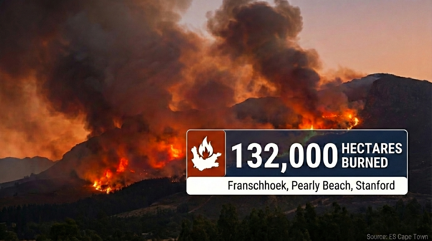
Live Update • 26 January 2026 Western Cape Wildfires: Worst Season in a Decade 132,000 hectares burned province-wide as Cabinet requests disaster declaration. Franschhoek fire…
Read Article
Wildfires in Western Cape - What is the situation 19 January 2026?
Photo courtesy of: Jeff Schmaltz, MODIS Land Rapid Response Team, NASA GSFC, Public domain, via Wikimedia Commons NEW UPDATE Newest compiled information is here: Read…
Read Article
Western Cape Wildfires Update: 15 January 2026
Photo courtesy of: SkyPixels, CC BY-SA 4.0, via Wikimedia Commons Cape Town • Western Cape • Summer wildfires • Peninsula + Winelands + Overberg Western…
Read Article
Why Is It Burning in Cape Town?
Photo courtesy of: Warren Rohner, CC BY-SA 2.0, via Wikimedia Commons Cape Town • Summer wildfires • Signal Hill, Table Mountain, the Cederberg Why Is…
Read Article
Cape Town Cycle Tour 2026 (a.k.a. „Argus“): Visitor Guide to Riding the Cape Peninsula
Photo: “Cape Town Cycle Tour 2024, cyclists on Chapman’s Peak” by Olga Ernst, CC BY-SA 4.0 , via Wikimedia Commons Cape Town • Road Cycling…
Read Article