Everything you need to know about Western Cape Whale Season
May 17, 2026
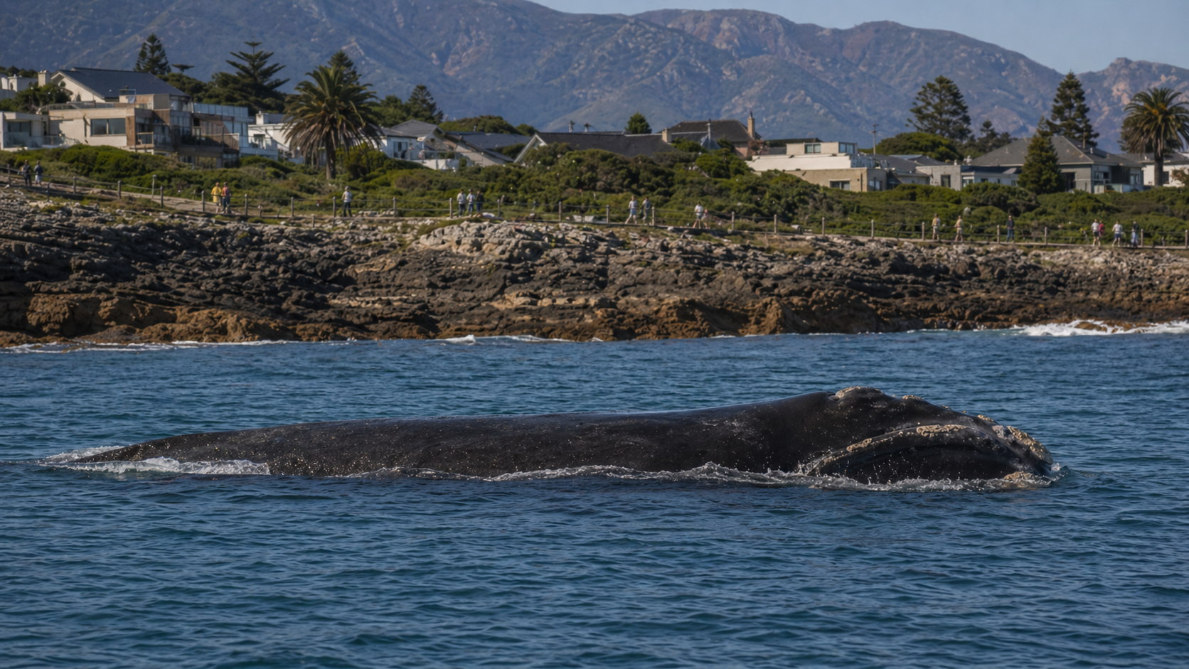

Cape Town's 2026 whale season: where to watch, when to go, and what 56 years of aerial surveys are starting to reveal
Each winter, Southern Right whales migrate north from sub-Antarctic feeding grounds (the cold seas surrounding Antarctica) to calve, or give birth, along the South African coast. Cape Town and Hermanus are among the most accessible whale-watching sites in the world, with the animals frequently visible from cliff paths within metres of the shoreline. Behind the spectacle sits one of the longest continuous studies of any marine mammal on record. Since around 2015, that study has been documenting something new: a textbook conservation recovery that has begun to diverge from its expected trajectory. This article sets out the practical guide to the 2026 season, and the data underneath it.
vs 1980s
since 2019
from 60 in 1935
since 1969
- Timing. The season runs from late May through November, with the biological peak between mid-August and early October. The single highest-yield week, by aerial-survey design, is the last week of September.
- Cape Town, free of charge. Metrorail's Southern Line follows the False Bay coast from the city centre to Simon's Town. Whales are regularly visible from Muizenberg, the Kalk Bay harbour wall, Boyes Drive, Jager's Walk in Fish Hoek, and the Simon's Town waterfront, all reachable in a day.
- The Whale Coast. Hermanus, two hours' drive east of the city, is the most reliable land-based whale-watching coastline in the world. Its 12 km cliff path delivers close-shore sightings without a boat. Catamaran trips from the New Harbour cost approximately R1,400 in 2026.
- The under-visited nursery. Koppie Alleen, in the De Hoop Marine Protected Area 175 km east of Hermanus, holds the densest concentration of mother-calf pairs anywhere on the African coast. Access is restricted; visitor volumes are negligible.
- The data behind the season. Breeding females are now approximately 23 percent lighter than their predecessors in the late 1980s. Calving intervals have lengthened from three years to four or five. Annual counts have varied by a factor of five since 2015. The whales continue to return each winter, but the population is no longer behaving as a stable recovery.
Forty years of recovery, then ten years of swings
Annual aerial survey count of cow-calf pairs along the southern Cape coast, 1969 to 2025. The recovery curve through the 1970s, 1980s, and 1990s reads as a textbook conservation success. From 2015 onward, the count has swung by a factor of five in just six seasons. Sources: MRI Whale Unit (University of Pretoria); CapeNature 2025 annual survey report.
Source: Mammal Research Institute Whale Unit, University of Pretoria. Annual aerial survey of cow-calf pairs flown each spring between Nature's Valley and Muizenberg. Reference values for 2019 (95 pairs), 2023 (556 pairs), and 2025 (128 pairs) are confirmed in the published series; intermediate years are reconstructed from the long-run trend.
Five facts before the practical guide
When the whales are here, week by week
Section 1 · The calendarMost operator-facing content reduces the season to a single phrase: "June through November, peak in September and October." The phrase is not wrong, but it is not particularly informative. The five months differ from one another in biology, in expected numbers, and in the probability of the encounter most visitors come for: a mother with a young calf, close to shore. The chart below traces the season arc the 56-year aerial survey describes. The cards beneath it set out, month by month, what each phase actually looks like on the water.
The 2026 season arc, week by week
Relative whale presence along the False Bay and Walker Bay coasts, calibrated against the long-run survey series. Annotations mark the biological events that drive the curve: arrivals, calving onset, calving peak, mating overlap, the MRI Whale Unit's principal aerial survey week, the Hermanus Whale Festival, and the early-departure window that has shortened the late-October tail over the past decade.
Source: relative-intensity curve calibrated against MRI Whale Unit aerial survey data (1969 to 2025) and operator-reported sighting rates. Survey-week and festival annotations from MRI Whale Unit, CapeNature 2025, and Hermanus Whale Festival 2025.
Late Mayweeks 21 to 22
Pre-seasonJuneweeks 23 to 26
ArrivalJulyweeks 27 to 30
BuildingAugustweeks 31 to 35
HighSeptemberweeks 36 to 39 · peak
★ PeakOctoberweeks 40 to 43
Mating & fadingNovemberweeks 44 to 48
DepartureViewing conditions, in three lines.
Wind. The Cape Doctor, the strong south-east summer wind that blows off Table Mountain and dominates Cape Town from November to March, is rarely the limiting factor in winter. The bigger constraint between June and September is weather fronts arriving from the north-west, which bring rain, swells over four metres, and visibility dropping below two kilometres. Most boat operators publish their sea-state cancellation thresholds and will refund or rebook.
Light. Morning is best for the south-facing viewpoints of False Bay and the Hermanus cliff path. Light is behind you, the wind is at its calmest of the day, and there is no glare off the water. Late afternoon is workable but glare is a real issue from any west-facing position.
Crowds. The September peak coincides with the European school holidays and South African school holidays. Booking accommodation in Hermanus two months ahead is sensible for the last week of September.
Where to watch from Cape Town itself
Section 2 · False Bay viewingThe standard advice is to drive to Hermanus. It is not wrong. But it treats False Bay as the place you sleep before going whale watching, rather than the place where whale watching is already happening. The MRI Whale Unit's annual aerial survey ends at Muizenberg, not because the whales stop there, but because Muizenberg marks the western boundary of the survey area. The breeding ground reaches into False Bay every year, and the False Bay coast is accessible by suburban train in a way that almost no other whale-watching destination on Earth can match.
False Bay is bounded by the Cape Peninsula in the west and the Hangklip headland in the east. The bay is shallow, sheltered from the prevailing winter NW swells, and has a soft sandy bottom along its northern shore. These are the conditions Southern Right whales prefer for calving: cold enough to stay within their thermal tolerance, calm enough to nurse, close enough to shore to deter predators. The mother-and-calf pairs you see from the False Bay coast in August and September are not strays. They are using the same nursery the survey is monitoring, at its western edge.
The False Bay coast: Muizenberg to Simon's Town
Metrorail's Southern Line runs along the False Bay coast from Cape Town station through Muizenberg, St James, Kalk Bay, Fish Hoek and on to Simon's Town. The train is cheap (R10 to R20 one-way depending on the station and class), runs roughly every 30 to 45 minutes weekdays between 5 am and 7 pm, and the seats on the left of the southbound carriage face the water for almost the entire 40 km journey.
Two caveats apply in 2026. Saturday service runs only to Fish Hoek, with a shuttle continuing to Simon's Town. Sunday service is suspended outside the December-to-January summer programme. Weather-related infrastructure damage between Fish Hoek and Simon's Town has caused intermittent disruptions through autumn 2026. Check the day's status on cttrains.co.za before relying on it.
When it is running, the train is the best low-cost whale-watching access route on the continent.
Muizenberg, Surfer's Corner. The promenade and the elevated boardwalk give a wide-angle view of the bay's northern reach. Sightings are intermittent through July and become regular from mid-August onward. Light is best before 11 am.
St James and Dalebrook. The tidal-pool wall is an underrated platform. Whales pass within 200 m of shore here several times a week in peak season, and the rocks immediately east of the pool give an elevated angle without driving up to Boyes Drive.
Kalk Bay harbour wall. The wall projects nearly 200 m into the bay and brings you as close to the water as you can get without a boat. Whales feeding or resting in the kelp beds just offshore are sometimes within 50 m of the wall. The harbour also has the best coffee and the best fried-fish lunch on the line.
Boyes Drive. The road contour above Kalk Bay and St James gives the best elevated angle on the central False Bay coast. Pull off at any marked viewpoint. Binoculars are worth carrying here, though peak-season cow-calf pairs are often visible without them.
Fish Hoek, Jager's Walk. The cliffside path between Fish Hoek and Sunny Cove gives a long, low-elevation view of the bay's southern reach. Quieter than Kalk Bay and the wind exposure is lower.
Simon's Town and Boulders Beach. The main road in Simon's Town runs hard against the water; the parking areas double as viewing platforms. Boulders is famous for African penguins, but the boardwalk gives a 270-degree view of False Bay's southern bowl, where some of the most photogenic late-season sightings happen.
Cape Point Reserve
Cape Point itself is a 90-minute drive from the city centre, requires the reserve entry fee (R400 international, R95 South African in 2026), and is not reachable by public transport. That last point is exactly why it is the highest-quality viewing on the peninsula. The cliffs put you 80 to 200 m above the water. Whales here are usually visible without binoculars when they are present.
Buffelsbaai. On the False Bay side of the reserve. The sheltered cove is a known nursery sub-area and has a small parking lot above it. Worth a stop on any reserve visit between July and October.
Olifantsbosbaai. On the Atlantic side. Wind exposure is real but on a calm morning this is one of the most spectacular viewing locations on the peninsula. Humpbacks pass here from June onward.
The lighthouse path. The walk from the lower funicular station up to the old lighthouse gives elevated south-facing views over the convergence zone where the Atlantic and Indian Ocean systems meet. Whales pass below regularly in season.
Practical routing
If you have one day in Cape Town and a car, the loop is: Boyes Drive in the early morning for the central False Bay panorama, Kalk Bay harbour wall for late morning, lunch in Kalk Bay or Simon's Town, then Cape Point Reserve in the early afternoon for the elevated cliff viewing. Allow 45 minutes from Simon's Town to Cape Point and an hour from Cape Point back to the city centre.
If you have one day and no car, take the Southern Line to Simon's Town, walk to the Boulders boardwalk, return to Kalk Bay for lunch and the harbour wall, then St James for late-morning viewing on the return leg. Total transport cost under R50, viewing free at every stop. Verify the day's service status before leaving.
Bring layers, a wind shell, and a flask. The False Bay coast is exposed to winter NW fronts and you will be standing still. Light is best from the south-facing viewpoints in the morning and the early afternoon; by 3 pm in winter the sun is already low enough to wash out anything looking east.
Categorised markers across False Bay, Cape Point Reserve, the Hermanus cliff path, and the De Hoop nursery. Toggle categories with the layer control; tap any marker for site notes, best months, and access.
Hermanus and the Whale Coast
Section 3 · Whale CoastIf False Bay is the western edge of the breeding ground, Hermanus is its heart. The 12 km cliff path along the Walker Bay shoreline is widely cited as the best land-based whale-watching coastline in the world, and the case is hard to argue with. Whales calve in the bay; the shore drops into deep water close to land; mother-and-calf pairs are visible from coffee shops. The town has built a culture around it, including the Whale Crier, who walks the cliff path during peak season and blows a kelp horn to alert watchers to sightings (the sound code differs by area of the bay).
Hermanus is 120 km southeast of Cape Town along the N2 and the R43, a drive of just under two hours under normal traffic. The scenic alternative is the R44 along the coast via Gordon's Bay, Rooi-Els and Pringle Bay, which adds 30 to 45 minutes but is one of the more spectacular drives in the country. Whale spotting from the car pull-offs along Clarence Drive between Gordon's Bay and Rooi-Els is regular in season.
What to do from Hermanus itself
The cliff path is free. It runs from Grotto Beach in the east, through Voëlklip, Kammabaai, the Old Harbour and Gearings Point, to the New Harbour. Gearings Point and the small Old Harbour Museum precinct concentrate the highest density of close-shore sightings in the bay. Kraal Rock, slightly further west, is where the whales most reliably approach within 30 m of the cliff.
The Old Harbour itself is small and now mostly a museum. The New Harbour, 1 km west, is where the boat operators launch. Walking the cliff path between the two takes about 45 minutes at viewing pace and remains the highest-yield use of a Hermanus afternoon during peak season.
Boat-based viewing from Hermanus
Two operators run from the Hermanus New Harbour during the Southern Right season. Southern Right Charters has operated since 1999 and runs three daily departures (typically 9 am, 12 pm and 3 pm) on the catamaran Miroshca, a 2-hour tour. Current 2026 pricing through third-party booking platforms is around USD 74 per adult, roughly R1,400 depending on the day's exchange rate. Whale specialist on board, light refreshments, optional purchase of the tour's video recording. The 9 am departure is the most likely to actually go: sea state limits trips and conditions typically deteriorate through the day.
Hermanus Whale Watchers runs from the same harbour on the Unathi catamaran with a similar format and price range. Both operators report sighting success rates above 95% during peak season (August through October). South Africa's legal minimum approach distance to a whale is 300 m for any vessel, drone or aircraft, but the whales themselves regularly approach the boats and the close-up encounter most visitors remember is whale-initiated.
The Gansbaai option: Marine Dynamics
Gansbaai is 40 minutes further east, between Hermanus and Cape Agulhas. Marine Dynamics (operating as Dyer Island Cruises for the whale tour) departs from Kleinbaai harbour for a 2.5-hour Marine Big 5 trip across the 8 km channel to Dyer Island and Geyser Rock. The Marine Big 5 is a Gansbaai-coined parallel to the African Big 5 of land safari, covering whales, sharks, seals, dolphins, and African penguins. The selling point is the species mix: alongside Southern Rights in season, you have a 60,000-strong Cape fur seal colony, the endangered African penguin breeding colony on Dyer Island, three resident dolphin species, and the great white shark presence (with the caveat below).
Pricing includes a R150 conservation fee that goes directly to the Dyer Island Conservation Trust, which funds the African Penguin and Seabird Sanctuary in Kleinbaai. Marine Dynamics is one of two whale-watching operators in South Africa with Blue Flag boat certification and has held Fair Trade Tourism certification since 2008. A marine biologist sails on every trip. Transfers from Cape Town run around R350 each way; alternatively, drive (200 km, two hours) or stay overnight in Gansbaai before an early launch.
The great white shark caveat. The operator publishes it openly: great white shark behaviour in the Gansbaai area has shifted since around 2017, when orca predation began affecting the regional population. Sightings can no longer be guaranteed. Bronze whaler and broadnose sevengill sharks are present year-round, and the seal and penguin elements of the Marine Big 5 are unaffected. The orca-and-great-white story is one of the more striking Cape Town marine-ecology data narratives of the past decade and is worth knowing about before the trip.
The Hermanus Whale Festival
The festival is now in its mid-thirties as an annual event and draws between 75,000 and 130,000 visitors over three days. The 2026 dates were not yet officially confirmed by mid-May; the festival traditionally falls on either the last weekend of September or the first weekend of October. The 2025 edition ran 3 to 5 October. Confirm via hermanuswhalefestival.co.za before booking accommodation. The festival itself is free to attend; specific marquees, the music programme and certain events carry tickets.
If you are planning a trip around the festival rather than the whales, the practical caveat is crowds. Hermanus has roughly 30,000 permanent residents; tripling that for three days produces traffic, parking and accommodation pressure across a 50 km radius. Booking lodging by July for a September or October festival weekend is realistic.
The further coast: De Hoop and Witsand
The MRI Whale Unit's surveys identify Koppie Alleen in the De Hoop Marine Protected Area, 175 km east of Hermanus, as the single most concentrated Southern Right nursery on the South African coast. The August 2025 preliminary aerial count recorded 70 cow-calf pairs at Koppie Alleen alone, more than triple the Walker Bay total of 21 from the same flight. De Hoop is undeveloped, requires reserve fees, and the final 30 km of access road is gravel. Accommodation is limited to the reserve's Opstal and Lekkerwater lodges and a few self-catering options.
For visitors with three or four days, an overnight at De Hoop and a sunrise viewing at Koppie Alleen is the highest-quality, lowest-crowd whale experience available on this coast. Almost no tour operators include it because of access friction, which is exactly why the wildlife density is what it is.
The data behind the season
Section 4 · The 23% storyEach spring since 1969, researchers from the Whale Unit at the University of Pretoria's Mammal Research Institute have flown the southern Cape coast in a helicopter, counting Southern Right whales between Nature's Valley and Muizenberg. From 1979 they added photo-identification. Every Southern Right carries a unique pattern of callosities, the rough white skin growths on its head, which function as a permanent identifier and allow individual animals to be tracked across decades. The resulting time series, now 56 years long, is among the longest continuous datasets ever compiled on any marine mammal.
The headline number is a conservation triumph. Commercial whaling on the South African coast ended in 1935, by which point the breeding population, the adult females able to give birth, had collapsed to roughly 60 individuals. By 2025 it had recovered to about 6,500 animals, growing at approximately 6.5 percent per year for several decades. That is the textbook account. Since around 2015, however, the curve has begun to wobble in ways the historical record does not account for.
Two indicators have shifted. The first is the annual count of mother-calf pairs along the surveyed coast, which has become highly volatile. In 2019 the survey recorded 95 pairs, the second-lowest figure since 1995. Four years later, in 2023, the count reached 556, the highest in the series. The 2025 survey, flown over three days in late September, recorded 128 pairs and 11 unaccompanied adults. Within six years, the count has swung by a factor of more than five. Prior to 2015, the series had displayed no comparable variance.
The second is the condition of the whales themselves. In a 2023 study, Dr Els Vermeulen, who leads research at the Whale Unit, and her colleagues used the survey photographs to measure adult females and compared them against equivalent images from 1988 and 1999. Animals arriving on the coast today weigh, on average, approximately 23 percent less than those measured three decades earlier. A 2024 follow-up estimated the decline at closer to 25 percent. Calving intervals have also lengthened. A healthy female used to give birth every three years; the interval is now four to five.
Breeding females are 23% lighter than in the 1980s
Body-condition comparison between adult females photographed from the air in 1988 and 1999 and those photographed in 2019 and 2021, using the same long-running survey. The decline is the simplest explanation for both the lengthening calving intervals (the gap between successive births) and the volatility in annual counts. Source: Vermeulen et al., Scientific Reports, 2023; MRI Whale Unit aerial photography archive.
Source: Vermeulen et al., Scientific Reports (2023). Distributions are stylised representations of the 23% mean shift reported by the study; not raw data.
Why mothers are 23 percent lighter: the krill story
Weight matters because of how Southern Rights feed. They are seasonal eaters. Almost the entirety of an adult's annual food intake is consumed during a few summer months in the Southern Ocean, primarily as krill, the small shrimp-like crustaceans that drift in dense swarms through the polar seas. The animals then migrate north to South Africa to calve and nurse, and they fast for the duration of the trip, often six months or more. They live entirely on the fat reserves accumulated at sea.
A nursing calf can consume up to 600 litres of milk a day and gain 3 cm of body length in 24 hours. A mother arriving on the Cape coast in poor condition has limited options. She can run out of milk and wean her calf prematurely, or she can skip that breeding cycle altogether. Both outcomes are now being recorded. Some calves are leaving South African waters before reaching the 8 m length they typically require to complete the migration south.
The cause most consistent with the evidence sits roughly 6,000 km south of Hermanus, in the Antarctic feeding grounds. The amount of krill in the Southern Ocean has declined and become more variable as the climate has warmed and sea-ice patterns have shifted. Satellite tags fitted to 34 adult whales in Walker Bay since 2019 show animals foraging well beyond their historical feeding zones. One female, tagged off the Cape coast, was tracked across the South Atlantic to the coast of South America before her tag stopped transmitting (Vermeulen et al., Marine Mammal Science, 2024). It was the first time any Southern Right whale had been recorded crossing an entire ocean.
South Africa is not the only site to register the change. The Australian Southern Right population, which constitutes the species's other major breeding ground, shows the same pattern. Annual births there have stagnated since 2016, and the number of non-breeding whales visiting the Australian coast fell by 66 percent between 2011 and 2024 (Agrelo et al., 2024). Whichever signal is propagating through the Southern Ocean food supply, both major branches of the species are responding simultaneously.
The practical question for a 2026 visitor is what to expect. The seasons no longer follow a regular pattern. The arithmetic of calving intervals suggests 2026 should be a relatively strong year, because most females who skipped 2025 will be due to give birth. But the past ten years of data have repeatedly produced the opposite of expectation. The honest position is that this year's count cannot be inferred from last year's. What can be inferred is the calendar. The whales arrive from June. Calving peaks in August and September. The last week of September remains the most reliable interval to be standing on the Hermanus cliff path when a 40-tonne mother breaches a hundred metres offshore.
Nature's Valley to Muizenberg
of the SA breeding population
by a Southern Right calf
of a nursing calf
What 2026 will look like
Section 5 · ForecastAn honest forecast for 2026 is difficult to give. The post-2015 volatility means a strong 2023 was followed by a weak 2025, and a weak 2025 carries no reliable implication for what follows. The Whale Unit's working assumption is that most females who skipped 2025 will be ready to breed again in 2026 or 2027, making a moderate-to-strong year plausible on biological grounds. Each of the past three seasons, however, has produced the opposite of the prior season's expectation.
What remains predictable is the calendar. Arrivals begin along the False Bay and Walker Bay coasts in late May and June. Mother-calf pairs become visible from the cliff paths by mid-July. The biological peak sits between the last week of August and the first week of October. The Hermanus Whale Festival, whatever its 2026 dates, will fall inside that window. Departures from South African waters now begin earlier than the older textbooks describe, somewhere in mid-October, and counts decline through November.
What is not predictable is the magnitude. The krill dynamics that underlie the 23 percent body-condition decline are themselves volatile year to year. They are conditioned on the El Niño cycle (the periodic warming of the Pacific that shifts weather across the globe), on the annual extent of Antarctic sea ice, and on the timing of the polar productivity window (the short summer period when plankton blooms feed the entire polar food chain). The whales are responding to a changing ocean, and that response is now visible from one survey to the next rather than only as a long-term trend. That is what gives the 56-year dataset its scientific value, and what makes any single-season forecast a wager rather than a prediction in the strict sense.
The strongest single recommendation this article can make is the one implicit in the MRI Whale Unit's survey design: book the last week of September. The aerial survey is timed for that interval precisely because mother-calf density along the coast peaks then. Whether the 2026 count proves a 2019-style trough or a 2023-style record, the last week of September will remain the highest-probability week to be on the cliff path.
Frequently asked questions
FAQSources and methodology
Primary scientific sources
- Mammal Research Institute Whale Unit, University of Pretoria. Annual aerial surveys, Nature's Valley to Muizenberg, 1969 to 2025. Photo-identification catalogue from 1979.
- Vermeulen, E. et al. (2023). Body condition changes in southern right whales. Scientific Reports 13, 3228. The 23% body-condition figure comparing 1988-1999 and 2019-2021 cohorts.
- Vermeulen, E. et al. (2024). Swimming across the pond: first documented transatlantic crossing of a southern right whale. Marine Mammal Science 40, 309-316.
- Vermeulen, E. et al. (2020). Decadal shift in foraging strategy of a southern right whale population in the South-West Indian Ocean. Global Change Biology.
- Agrelo, M. et al. (2024). Ocean warming threatens southern right whale population recovery. Science Advances. The 66% Australian non-breeding decline figure.
- CapeNature, 2025 annual Southern Right whale aerial survey report.
- The Bateleurs / MRI Whale Unit, August 2025 preliminary gyrocopter count (Hermanus to Witsand).
Operators and visitor information
- Southern Right Charters, Hermanus. Operating since 1999. Catamaran Miroshca. Pricing verified via GetYourGuide and Tripadvisor (May 2026).
- Hermanus Whale Watchers, Hermanus. Catamaran Unathi.
- Marine Dynamics / Dyer Island Cruises, Kleinbaai (Gansbaai). Fair Trade Tourism certified since 2008.
- Cape Town Tourism and Hermanus Tourism, visitor data and festival information.
- Hermanus Whale Festival, official site for 2026 dates and programme.
- Metrorail Western Cape, Southern Line operational status via cttrains.co.za.
- CapeNature, reserve fees and accommodation for De Hoop Marine Protected Area.
- SANParks, Cape Point Reserve fee schedule.
Internal links
- Cape Town safety guide 2026
- Cape Town safety hub
- Coastal spillover: Hermanus, Langebaan, the Garden Route
- Cape Town's data centre boom: 580 MW, 34% of city power
Methodology. Whale population figures use the MRI Whale Unit's published series as the canonical source. The 23% body-condition figure is from Vermeulen et al. (2023, Scientific Reports); the same group's 2024 follow-up estimates the figure closer to 25%, and the present article uses the lower-bound published number. Annual cow-calf pair counts are from the late September / early October aerial survey flown between Nature's Valley and Muizenberg. Operator pricing reflects published rates as of May 2026 and is subject to seasonal change. ZAR-USD reference rate (May 2026): R 1 ≈ $0.053. All conclusions and interpretations are the responsibility of the author.
Whale Watching Map — 2026 Season
You May Also Like

Where Are South Africans Emigrating? Data-Driven Analysis 2026
Photo courtesy of Nic0, Wikimedia Commons, licensed under CC BY-SA 3.0 Global Diaspora · Migration Data Analysis · South Africa 2026 Where Are South Africans…
Read Article
What Is South Africa's New Traveller Declaration?
Travel Guide · South Africa What Is South Africa's New Traveller Declaration? From today, 1 July 2026, everyone who enters or leaves South Africa has…
Read Article
How Bad Were the June 30 Marches? Cape Town and South Africa 2026
Aftermath · 1 July 2026 How Bad Were the June 30 Marches? For weeks South Africa braced for another 2008. On the day itself, the…
Read Article
Cape Town and the June 30 Anti-Immigration Marches: What Is Happening
Situation Briefing · Cape Town The June 30 Anti-Immigration Marches: What Is Happening, and What Visitors Should Know Anti-immigration groups have set 30 June 2026…
Read Article
Is Cape Town's container port really bad?
Hero image: the working harbour at the Port of Cape Town · Frans-Banja Mulder, CC BY 3.0 , via Wikimedia Commons Editorial feature · capetowndata.com…
Read Article