Why Is It Burning in Cape Town?
January 10, 2026

Photo courtesy of: Warren Rohner, CC BY-SA 2.0, via Wikimedia Commons
Cape Town • Summer wildfires • Signal Hill, Table Mountain, the Cederberg
Why Is It Burning in Cape Town?
Wildfires around Cape Town are most common in summer, when months of dry weather lower fuel moisture and strong winds can spread fire quickly. In the Cape Peninsula and nearby mountain regions, fires can lead to smoke, temporary road and trail closures, and disruptions to outdoor plans. This guide explains why summer is the high-risk period, what has burned recently, how to use satellite tools to check active fire detections, and what visitors should pay attention to when hiking or driving near wildland edges.
Cape Town’s wildfire season is largely a summer issue: fuels dry out over weeks, winds increase spread, and most ignitions are linked to human activity. The best travel approach is practical: check fire danger, confirm park/trail status, and avoid closed areas.
Quick check before hikes: (1) SAWS Fire Danger Index and (2) park/trail status. For active detections, use AFIS or NASA FIRMS.
1) The summer drivers: dryness, heat, wind, and ignition
The Western Cape has a Mediterranean climate: most rain falls in winter, while summer is typically dry. By late December and January, vegetation and ground fuels have had weeks (sometimes months) to dry. That reduces fuel moisture and makes ignition easier, especially on hot days.
Fire risk also rises with wind. In the Cape Peninsula, wind can increase the speed of spread and make spotting more likely (embers starting new fires ahead of the main front). When those conditions align with an ignition source—often human-caused—the result can be a fast-moving incident and temporary restrictions on roads and trails.
Simple model: dry fuels + heat + wind + an ignition source. Summer increases the first three, which is why prevention and situational awareness matter most in this season.
2) Wind and topography: why fires spread fast on the Peninsula
Cape Town’s terrain matters. Fires spread faster uphill, and the Peninsula has steep slopes and ridgelines that can channel wind. Wind can also limit ground access and complicate aerial firefighting. In practice, this is why small fires can escalate quickly when wind speeds increase.
For visitors, the immediate impact is usually operational: trail closures, restricted access, and smoke drifting into popular areas depending on wind direction. If you are planning a hike, treat wind as a core variable, not a background detail.
3) The fuel: fynbos, fire cycles, and invasive plants
Much of the Cape’s natural vegetation (including fynbos) is fire-adapted. Fire can be part of the ecological cycle, but frequency and timing matter. Fires that occur too often, or under extreme conditions, can cause ecological damage and increase risk to nearby communities.
In addition, invasive alien plants can change fuel loads and fire behavior in some landscapes. This can raise intensity and increase the difficulty of suppression in certain areas.
4) This summer: Signal Hill + the Cederberg
In early January 2026, a vegetation fire on Signal Hill was contained, with crews monitoring hotspots afterward. Incidents like this matter because they occur close to residential areas and popular visitor routes, and because wind can move smoke into different parts of the city.
In late December 2025, a large fire complex in the Cederberg burned a substantial area and required extended firefighting operations. Even when these fires are outside Cape Town, they can affect regional travel plans and can draw firefighting resources across the province.
| Where | What happened | Visitor impact (typical) |
|---|---|---|
| Signal Hill (Cape Town) | Vegetation fire contained; crews monitored hotspots afterward. | Short-notice restrictions and smoke impacts; avoid closed access points. |
| Cederberg (regional) | Large wildfire complex in late Dec 2025 with major burn area reported. | Access restrictions, detours, and changed plans for reserve visits; confirm before driving in. |
5) Last summer: Table Mountain, Tokai/Silvermine
In February 2025, fires in Table Mountain National Park led to a phased reopening of some routes while other sections remained closed for safety reasons. After a fire, hazards can include unstable slopes, falling rocks, damaged infrastructure, and poor visibility in smoke.
In April 2025, wildfires in the Tokai and Silvermine areas (also part of Table Mountain National Park) prompted additional closures and response activity. For visitors, the takeaway is consistent: park access can change quickly during summer, and official closure notices should be treated as final.
Closures are safety controls. After a fire, the risk is not only flames. Avoid closed trails and do not enter restricted areas.
6) Map: recent wildfire locations
The map below marks a handful of recent incidents and provides direct links to satellite tools (AFIS, FIRMS, Worldview) so you can check conditions. The pins are for general orientation rather than official fire perimeters.
7) What visitors should pay attention to
A practical checklist for summer days
Fire Danger Index Wind Closures Smoke
1) Check the Fire Danger Index. If ratings are high, reconsider exposed hikes and avoid remote routes without clear exits.
2) Check trail and road status. In summer, closures are common and can change within a day.
3) Treat smoke as a real signal. If smoke is heavy, reduce outdoor exertion; if you have asthma, plan indoor alternatives.
If you plan to hike
If you’re driving out of the city
8) How visitors should behave in a dry Cape summer (and who to contact if you spot a wildfire)
Summer in the Western Cape is often dry and windy. In those conditions, small mistakes can start fires and make them harder to control. Visitors do not need specialised knowledge. They need consistent habits.
Behave like ignition is easy
Behave like access matters
If you spot smoke or a wildfire, report early. Early reports often make the difference between a short response and a long incident.
When you call, provide: (1) your exact location (drop a GPS pin if possible), (2) nearest landmark/trail/road, (3) what is burning (bush/trees/building), (4) approximate size and direction of spread (wind direction helps), and (5) any immediate risks (homes, hikers, powerlines). If safe, a photo from a distance can help dispatchers.
| Where you are | Who to call | Use this when |
|---|---|---|
| Cape Town (City area) | 107 (landline) or 021 480 7700 (cellphone) | To report fires, smoke, flooding, rockfalls — or any urgent city emergency. |
| Table Mountain National Park (TMNP) | 086 110 021 (SANParks emergency) or 021 689 7438 (Newlands Fire Base) | To report fires or suspicious activity inside TMNP, including Signal Hill and major hiking corridors. |
| Elsewhere in the Western Cape |
112 (cellphone national emergency) or call the closest district line Overberg: 028 425 1690 • West Coast: 022 433 8700 • Eden: 044 805 5071 Central Karoo: 023 414 2603 • Cape Winelands: 021 887 4446 |
If you are outside the metro area, or unsure which service has jurisdiction. Use district lines when you know your area. |
| If there is immediate danger | 112 (cellphone) | Life-threatening situations, evacuations, people trapped, fire in close proximity. |
Do not attempt to fight a wildfire. Move to a safe location first, then report. Keep roads clear and follow official instructions if evacuations or closures are issued.
9) Live maps + sources
Live / near real-time tools:
Sources used for incident reporting + context:
- Western Cape wildfire season stats: https://www.westerncape.gov.za/local-government/article/western-cape-records-more-fires-fewer-hectares-past-wildfire-season
- Signal Hill incident coverage: https://www.ewn.co.za/2026/01/04/signal-hill-fire-under-control-but-firefighters-working-to-contain-hotspots
- Cederberg fire update: https://www.capenature.co.za/news/cederberg-fire-complex-update
- Table Mountain closures (Feb 2025): https://www.ewn.co.za/2025/02/27/table-mountain-fires-platteklip-gorge-and-kloof-corner-trails-reopen-all-trails-in-newlands-forest-remain-closed
- Tokai/Silvermine (Apr 2025) coverage: https://apnews.com/article/419adfc3283dfb8d4cfc9a36d40bb8c1
- Fire ecology background (CapeNature PDF): https://www.capenature.co.za/uploads/files/Landowners-Guide-to-Fire-Management-Fact-Sheet-English.pdf
- Emergency numbers (CapeNature fire management): https://www.capenature.co.za/fire-management
- TMNP reporting numbers (SANParks): https://www.sanparks.org/news/table-mountain-national-park-addresses-surge-in-fires
- Cape Town Public Emergency Communication Centre (107 / 021 480 7700): https://resource.capetown.gov.za/documentcentre/Documents/Procedures%2C%20guidelines%20and%20regulations/About%20Public%20Emergency%20Communication.pdf
Disclaimer: This article is for general travel information, not emergency guidance. For active incidents, follow official instructions and local emergency services updates.
More in Annual & Seasonal Events
- Western Cape Wildfires: Worst Season in a Decade Update 26 January 2026
- New Developments: Western Cape Wildfires Update 22 January 2026
- Wildfires in Western Cape - What is the situation 19 January 2026?
- Western Cape Wildfires Update: 15 January 2026
- Cape Town Cycle Tour 2026 (a.k.a. „Argus“): Visitor Guide to Riding the Cape Peninsula
- AfrikaBurn 2026: Building a Different Kind of Society in the Tankwa Desert
You May Also Like
Western Cape Wildfires: Worst Season in a Decade Update 26 January 2026
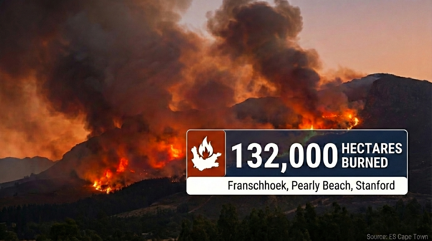
Live Update • 26 January 2026 Western Cape Wildfires: Worst Season in a Decade 132,000 hectares burned province-wide as Cabinet requests disaster declaration. Franschhoek fire…
Read Article
New Developments: Western Cape Wildfires Update 22 January 2026
Photo courtesy of: SkyPixels, CC BY-SA 4.0, Wikimedia Commons Western Cape • 19–22 January 2026 • Franschhoek CRITICAL • Signal Hill • Strand / Helderberg…
Read Article
Wildfires in Western Cape - What is the situation 19 January 2026?
Photo courtesy of: Jeff Schmaltz, MODIS Land Rapid Response Team, NASA GSFC, Public domain, via Wikimedia Commons NEW UPDATE Newest compiled information is here: Read…
Read Article
Western Cape Wildfires Update: 15 January 2026
Photo courtesy of: SkyPixels, CC BY-SA 4.0, via Wikimedia Commons Cape Town • Western Cape • Summer wildfires • Peninsula + Winelands + Overberg Western…
Read Article
Cape Town Cycle Tour 2026 (a.k.a. „Argus“): Visitor Guide to Riding the Cape Peninsula
Photo: “Cape Town Cycle Tour 2024, cyclists on Chapman’s Peak” by Olga Ernst, CC BY-SA 4.0 , via Wikimedia Commons Cape Town • Road Cycling…
Read Article