Limpopo–Mpumalanga Flooding: What’s safe, What’s Risky (18 Jan 2026)
January 18, 2026
Limpopo • Mpumalanga • Flooding + disruptive rain • Kruger National Park + Lowveld + Vhembe + Mopani
Limpopo–Mpumalanga Flooding: What’s Safe, What’s Risky (18 Jan 2026)
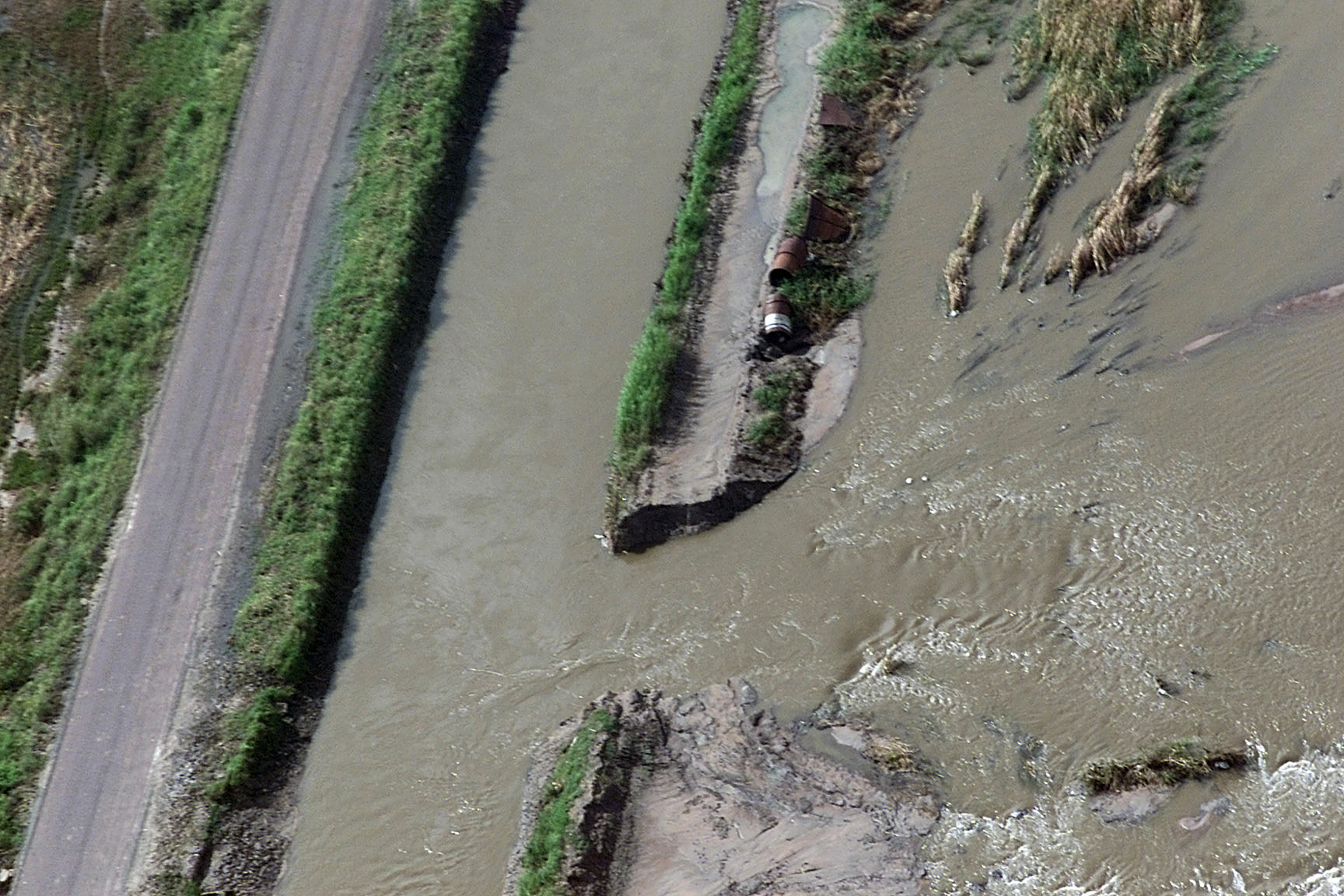
After weeks of intense rain, the north-east has moved from “wet season disruption” into a genuine flooding emergency.
Limpopo and Mpumalanga have taken the hardest hit — with washed-out roads, damaged bridges, displaced communities, and a knock-on effect
through river systems and dams. Kruger National Park was forced into closures and evacuations earlier in the week, and is now
moving into a phased reopening.
The big travel takeaway today: rainfall is easing in places, but ground is saturated, rivers are high, and several dams are
spilling or being managed with releases — which can keep flood risk elevated even after the clouds break.
Quick take (18 Jan): Rainfall intensity is easing in parts of the north-east — but flood risk remains high because rivers are already swollen and several key dams in Limpopo and Mpumalanga are over 100% or being actively managed with releases. Kruger National Park is shifting into recovery and reopening — with day visits set to resume on 19 Jan and some gates/regions still restricted.
Before you drive anywhere today: check (1) SAWS warnings, (2) SANRAL/provincial road alerts, (3) SANParks Kruger notices, (4) local municipality updates.
1) Overall: easing or still dangerous?
Easing in the sky — still dangerous on the ground. SAWS messaging on 18–19 Jan points to heavy rain easing over parts of the north-east, but with ongoing thunderstorms/showers and a continuing flood risk where soils are saturated and drainage is overwhelmed. Practically, this is the phase where travellers get caught out: blue patches appear, but roads fail late (wash-aways), and rivers peak after rainfall — especially downstream of dams releasing water.
Stable vs risky areas (a travel-first read)
2) Places at a glance (go / caution / avoid)
These are travel-style signals based on official alerts and public updates. Always confirm the latest official notice before you depart.
Polokwane (Limpopo urban hub)
Giyani + Phalaborwa corridor (Mopani)
Thohoyandou region (Vhembe)
Mbombela (Nelspruit) + Nkomazi (Mpumalanga Lowveld)
Kruger NP (South)
Kruger NP (North)
3) What’s happening by area (Limpopo • Mpumalanga • Lowveld river corridors)
Limpopo: Mopani + Vhembe (the highest disruption zone)
Limpopo’s Mopani and Vhembe districts have been repeatedly flagged as hardest hit in public reporting, with widespread flooding impacts on settlements, roads, and public infrastructure. In this phase, the most dangerous thing isn’t “big obvious water” — it’s compromised road edges and undermined bridges that look drivable until they suddenly aren’t.
Mpumalanga: Lowveld + escarpment (Mbombela, Nkomazi, Bushbuckridge / Hazyview, Graskop)
The Mpumalanga Lowveld has had significant flooding in communities (including around Komatipoort/Nkomazi) and intense rainfall on the escarpment. Reports earlier this week described exceptional daily totals in places like Graskop and Phalaborwa, which matters because it feeds river systems that run through Kruger and across the Lowveld.
Why the flood risk lingers after rain eases
Two things keep risk elevated: (1) Saturated catchments — every new shower becomes runoff; and (2) Dam spill + managed releases — when storage rises above full supply, operators may open sluices to protect dam safety, which can raise river levels downstream even if local rainfall has calmed.
4) Dam levels rising: where the water is building up (and why releases matter)
The Department of Water and Sanitation’s latest public update (14 Jan) shows multiple dams in Limpopo and Mpumalanga above 100%, with some already releasing water. These are not “fun facts” — they’re a downstream travel signal. If you’re camping near rivers, doing a border run, or driving low-lying roads, treat dam releases and swollen rivers as a reason to simplify your plan.
Data note: The dam percentages and release notes below reflect the latest DWS public statement available at the time of writing (14 Jan 2026). Levels can change rapidly after storms — confirm the newest official update before you travel.
| Area | Dam (key flood signal) | Latest level | Why travellers should care |
|---|---|---|---|
| Limpopo (Mopani / Sekhukhune / Vhembe) | Flag Boshielo (Olifants system) | 105.1% | Above full supply — raises downstream river risk, especially after additional showers. |
| Limpopo | De Hoop (Steelpoort/Olifants region) | 100.9% | At/above capacity — possible spill impacts on connected river corridors. |
| Limpopo | Tzaneen | 108% | High storage can mean higher flows downstream; avoid low bridges and river-edge roads. |
| Limpopo | Nandoni | 105% | DWS reported active discharge management — downstream rivers can stay high even after rain eases. |
| Limpopo | Albasini | 108% | Sluice gates opened mid-Jan in DWS update; be conservative around downstream crossings. |
| Limpopo (Vhembe) | Nsami | 166% | Exceptionally high reported level — assume high river hazard nearby; avoid floodplains and informal crossings. |
| Mpumalanga (provincial) | Grootdraai | 101.9% | Above capacity — downstream flow management can affect routes and low-lying roads. |
| Mpumalanga | Loskop | 101.6% | High storage; if you’re driving rural roads near rivers, keep detours and daylight buffers. |
| Mpumalanga | Rhenosterkop | 102.7% | Elevated level suggests persistent runoff; avoid “unknown” dirt-road crossings after storms. |
| Mpumalanga (Lowveld) | Blyderivierpoort | 106.1% | High level near major tourist routes; river systems can remain fast and dangerous. |
Important: If you’re downstream of a dam that is spilling or releasing, don’t camp on riverbanks, don’t wade, and don’t attempt river crossings — even if the weather looks “better” in your exact location.
5) Kruger National Park: what’s happening right now?
Kruger has had a rough week. Earlier updates described severe weather impacts including saturated internal roads, temporary closure of access for day visitors, and shutdown of at least one major camp (Satara) due to flooding impacts. The latest update (18 Jan) signals improvement — with a controlled reopening path.
Kruger travel reality check (18 Jan)
What’s open (per latest park update)
The park indicated access would route through Paul Kruger Gate, Numbi Gate, Malelane Gate, and Phabeni Gate (with Phabeni monitored). Crocodile Bridge Gate is listed as closed in the same update. Even when gates are open, treat gravel-road warnings as meaningful: saturated gravel can be slippery and can hide wash-outs.
What to expect inside the park
Expect “normal safari” to be muted in places: fewer road options, slower driving, detours, and possibly temporary closures of low-water crossings. In exchange, water-driven landscapes can be spectacular — but only if you stick to permitted routes and keep your risk appetite low.
6) Roads + transport: closures, fragile bridges, and “don’t gamble” routes
Flood travel is mostly a road problem — not a “rain problem.” Even moderate rain on saturated ground can knock out culverts, shoulders, and low bridges. Public reporting referencing SANRAL updates in Limpopo highlighted closures and high-risk routes around the Hoedspruit–Phalaborwa–Giyani corridor.
Rule that saves lives: Never drive through flowing water. “Only 10 cm” can stall a car; deeper water can float it; fast water can move it. If you can’t see the road surface, it’s not a road — it’s a river.
| Area | What’s been reported | Practical advice |
|---|---|---|
| Limpopo (Mopani) | Reported closures include R527 (Hoedspruit area) and R578 (south of Phalaborwa to Giyani), with additional roads listed as flooded or damaged. | Avoid regional detours. Use major routes only and confirm status before leaving town. |
| Mpumalanga Lowveld | Localised flooding and washed-out sections can appear fast, especially near rivers and drainage lines during thunderstorms. | Base in Mbombela/Hazyview and keep trips short. Skip scenic gravel loops until conditions stabilise. |
| Flights (Hoedspruit / Lowveld access) | Some services have been disrupted earlier in the event window (operators may cancel flights when weather and runway conditions deteriorate). | If you’re flying in, keep backup ground-transfer time and don’t stack tight connections. |
7) Where to go and where not to go (a practical visitor guide)
Where not to go (until warnings drop)
Riverbanks + floodplains Low-water bridges Gravel backroads Closed gates / closed roads Northern Kruger
1) Avoid river-edge accommodation and campsites in the Limpopo/Mpumalanga river corridors while dams are spilling or releasing.
2) Avoid “shortcut” routes through Mopani/Vhembe rural roads during thunderstorms and the day after.
3) Avoid Crocodile Bridge Gate for Kruger right now (listed as closed) — use the gates specified by the park in the latest update.
4) Avoid northern Kruger itineraries until the park confirms full access is restored.
Where you can go (lower risk options)
Urban bases Main tar routes Short loops Indoor backups South Kruger (with limits)
1) Choose an urban base (Mbombela, Polokwane) and do short, reversible day trips.
2) If doing Kruger: stick to the southern access gates named by SANParks and prioritise tar roads inside the park.
3) If you need a scenery fix: pick routes with strong services and clear turnaround points — and avoid “one-way” gravel roads through valleys.
4) Build a Plan B: museums, cafés, viewpoints on main routes — anything that avoids remote roads when storms pop up.
A 5-minute pre-drive checklist
If you’re already in a flood-affected area
8) Map: key locations mentioned
The map below marks key places referenced in this report (towns, gates, and selected dams). Pins are approximate and for visitor orientation only — not official flood extent or road status.
9) If you’re caught in flooding: quick safety basics
Do not drive through floodwater. Turn around. Avoid bridges with water at deck level. If you are in immediate danger, move to higher ground and call emergency services.
Emergency: 112 (cellphone) • 10111 (SAPS). Follow local municipal disaster management guidance if issued.
10) Live tools + sources
Live / near real-time tools:
Sources used for this 18 Jan overview (selected):
- SAWS warning + forecast notes via News24 (18 Jan): https://www.news24.com/southafrica/weather/mondays-weather-more-storms-in-limpopo-thunder-and-rain-expected-in-3-provinces-20260118-1023
- DWS statement (14 Jan) — Limpopo + Mpumalanga dam levels and releases: https://www.gov.za/news/water-storage-levels-improve-limpopo-and-mpumalanga-14-jan-2026-0000
- SANParks (18 Jan) — Kruger update, gates, day visits resuming 19 Jan: https://www.sanparks.org/parks/kruger/alerts/updates-on-kruger-national-parks-flood-affected-roads-and-camps
- SANParks (15 Jan) — severe weather warning context: https://www.sanparks.org/parks/kruger/alerts/update-on-severe-weather-warning-day-visitors-temporarily-suspended-in-kruger
- Road closures referencing SANRAL updates (Limpopo): https://limpopochronicle.co.za/2026/01/temporary-closure-of-affected-national-roads-in-limpopo-following-heavy-rainfall/
- Background rainfall context: https://www.theguardian.com/world/2026/jan/15/south-africa-floods-kruger-national-park-tourists-evacuated
Disclaimer: This article is general travel information, not emergency guidance. For active incidents, follow official instructions from SAWS, SANParks, SANRAL and local disaster management.
You May Also Like

Cape Town Tourism in 2026: Record Numbers, New Hotels, and the Risks Ahead
Photo courtesy of Dietmar Rabich, Wikimedia Commons, licensed under CC BY-SA 4.0 Cape Town Tourism in 2026: Record Numbers, New Hotels, and the Risks Ahead…
Read Article
MyCiTi Phase 2A: Can a Bus Route Fix Apartheid's Spatial Legacy?
Photo courtesy of Dietmar Rabich, Wikimedia Commons, licensed under CC BY-SA 4.0 MyCiTi Phase 2A: Can a Bus Route Fix Apartheid's Spatial Legacy? | Cape…
Read Article
What is going on politically in Cape Town and South Africa in 2026
Photo: Cape Town CBD skyline at dusk. Via Wikimedia Commons , CC BY-SA 4.0. Cape Town Data · Political Analysis Where Things Stand: South Africa's…
Read Article
What's up in Cape Town ? The Weekly | 23-29 March 2026
Edition #10 · 23-29 March 2026 The Cape Town Weekly Your guide to the Mother City Africa's Grandest Gathering returns to the CTICC on Friday…
Read Article
What is the City of Cape Town doing about the N2 safety issues?
Photo courtesy of Diego Delso, Wikimedia Commons, licensed under CC BY-SA 4.0 Where Does Cape Town's R84 Billion Go? | 2025/26 City Budget Analysis Municipal…
Read Article