Photo courtesy of Rehman Abubakr, Wikimedia Commons, licensed under
CC BY-SA 4.0
## Table of Contents
- [Meaning of the name “Platteklip Gorge”](#meaning-of-name)
- [Why Platteklip is So Popular (and How Many Hikers)](#popularity)
- [Safety on Platteklip: Recent Crime Stats](#safety)
- [Why Hike Instead of Cable Car](#cable-car)
- [Fitness and Difficulty: Who Can Do It?](#fitness)
- [What to Pack: Gear and Supplies](#gear)
- [Is Platteklip Dangerous? Risks to Consider](#danger)
- [Other Table Mountain Routes (India Venster, Skeleton Gorge, etc.)](#comparison)
- [Recommendation: Should You Hike It? Best Times to Go](#recommendation)
- [Summary Table: Route Stats](#summary)
more info on Wiki loc
## Meaning of the Name “Platteklip Gorge” {#meaning-of-name}
The name *Platteklip* comes from Afrikaans, literally meaning “flat rock” (platte = flat, klip = rock). In practice, the gorge is indeed full of giant sandstone slabs and ledges – flat rocks on and beside the trail. Ironically, though, the **trail itself is anything but flat**. The climb is a relentless ascent of stone steps up the front face of Table Mountain. So while the **rock formations** along the route are relatively flat and broad, hikers will find themselves scaling what feel like an endless staircase. (The trail was first ascended in 1503 – long before fitness trackers or sneakers!)
In short, the name is descriptive of the *terrain’s geology*, not the difficulty. Platteklip is a gorge cut through the mountain’s “flat” side, but your thighs will still feel the climb!
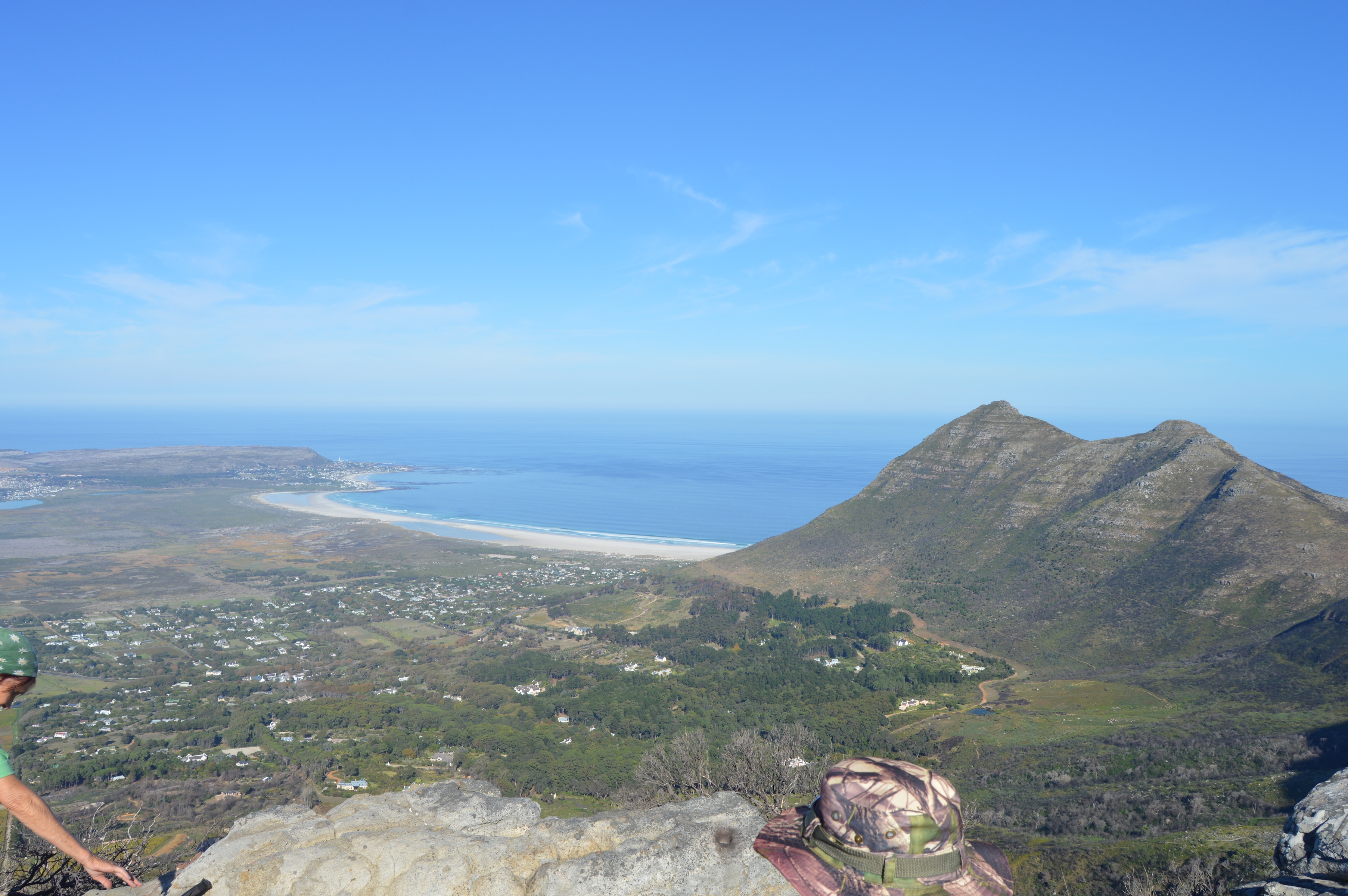
## Why Platteklip is So Popular (and How Many Hikers) {#popularity}
Platteklip Gorge is by far Table Mountain’s **busiest hiking route**. It is the *oldest, quickest, easiest and most direct* way to the summit. In one travel blog’s words, it’s nicknamed the “N1 highway” to the top – always busy. Thousands of local and international tourists ascend Table Mountain every year, and many of them use this trail. During the summer holiday season (December–February), it’s especially packed.
**Numbers:** Exact figures are hard to pin down, but the numbers are in the tens of thousands. For context, Table Mountain National Park as a whole attracts **millions** of visitors annually (about 4.2 million per year for all activities, with roughly 1.7 million just in Dec ’23–Jan ’24). The cableway alone carries about **1 million riders per year**. Many others climb on foot. Even if only a fraction of those walked up Platteklip, it easily means *tens of thousands of hikers* use this gorge trail each year. On any clear day you’ll pass fellow hikers the whole way up. Its popularity comes down to **convenience**: no rope or special gear is needed, the path is obvious, and it gains altitude very quickly.
Because it’s so direct, Platteklip’s trailhead (off Tafelberg Road, about 1.5 km past the cable car station) is always bustling. In fact, a recent travel post notes that cars line the road by 8 AM in high season, with hikers streaming out in groups. In short, if you want company (or prefer not to hike alone), Platteklip delivers.
## Safety on Platteklip: Recent Crime Stats {#safety}
Safety concerns have dogged Table Mountain in recent years. It’s important to be informed. **Official data** from SANParks indicates that the number of reported crime incidents on Table Mountain has actually fallen significantly over 2023–2024. In late 2023, there were dozens of recorded incidents per month on the mountain; by mid-2024 that number had dropped to single digits. For example, crime-related incidents affecting visitors went from 33 in November 2023, to 6 in December 2023 and only 1 in January 2024 (a drop credited to increased patrols and safety measures). This suggests the **official trend** is downward, and SANParks has emphasized that overall crime levels are relatively low.
However, **watchdog groups and news outlets** report that hikers still face a real risk. In late 2024 / early 2025, media cited *60 robberies* on Table Mountain between Nov 2024 and Jan 2025 – including *20 muggings in January 2025 alone*. (That works out to nearly one victim every day.) An NPO called “Friends of Table Mountain” has called for more patrols, noting that even with a slight official decline, the absolute numbers are still high for a park. These figures cover **the whole park**, not just Platteklip – but Platteklip Gorge, being the busiest trail, has been the scene of incidents. (For example, news reports have documented armed robberies of hikers on Platteklip in the past.)
So what does this mean for a Platteklip hiker? Stay vigilant. Most patrols and rescues focus on the main trails, but the terrain can be quiet if you hike alone or in small groups. The advice from SANParks is simple: **hike in groups, start early, and let someone know your route**. There have been no recent *statistical breakdowns* saying “X robberies in Platteklip last month,” but common sense applies: keep valuables hidden, consider not wearing flashy gear or jewelry, and hug the group. Many hikers deliberately run or power-walk up and down the route to minimize time on the trail, especially if alone.
In summary, Platteklip itself isn’t inherently more prone to crime than any other trail – it’s just the busiest. Take standard precautions: stay in a group, keep aware of your surroundings, and if you feel unsafe at any point, turn back or join others. Also note that emergency response (rangers and police) **does exist**; in one incident a robber on Platteklip was caught by rangers within 30 minutes. Finally, do **honor site warnings**: SANParks explicitly reminds hikers to start early, carry enough water, and choose popular times/routes when possible.
## Why Hike Instead of Taking the Cable Car {#cable-car}
For many visitors, the cable car is the easy ride to the top. So why would anyone pass it up to slog up 650+ meters on foot? **Several reasons**:
- **Experience & Fitness:** Some hikers want the sense of accomplishment. Climbing Platteklip is a classic Cape Town challenge – you can brag you summited “the hard way.” Many describe hiking as more *fun* or adventurous than just riding the tram.
- **Saving Money:** Taking the cable car isn’t cheap. An adult round-trip ticket costs on the order of **R400–R500** (roughly US $30–35), and lines or tickets can add hassle. Hiking is *free*. As one travel writer quipped, “If you’re a budget traveler or looking to save on expenses, hiking is a wonderful option for a free activity!”. In other words, your legs are your cable car.
- **Schedules and Closures:** The cable car frequently closes for maintenance and wind. In fact, every winter (July–August) the entire cableway shuts down for weeks, and on windy days it often halts for hours. If the cable car is closed, Platteklip is essentially the only safe exit from the mountain’s upper station. (In good weather it’s fast, but if you arrive to find “Closed – High Winds,” you’ll be hiking by necessity.) Some hikers prefer to ascend Platteklip *instead of using a shutdown cable car*.
- **No Waiting:** On peak days the cable car line can be very long (queues of an hour or more are not unheard of). By hiking, you skip the wait and start your adventure immediately.
- **Scenery & Connection:** Paradoxically, even though cableway provides stunning *static* views, many hikers say they enjoy feeling more connected to the mountain when walking up. Cable cars spin slowly, but you’re still sitting. Hiking lets you choose your own pace, stop to admire flowers or city views along the way, and truly “earn” the summit vista. (Full disclosure: not everyone is keen to hike the same route multiple times for fun, but a lot of Capetonians and outdoor-types do!)
In short, it’s not that the cable car is unsafe – on the contrary it’s very safe and popular – but a portion of hikers deliberately skip it for the workout, adventure, or cost savings. If you do decide to hike up Platteklip and ride the cable down, remember to **check the cable car status** before you go. Many visitors take the cable down at the end to save legs on the descent.
## Fitness and Difficulty: Who Can Do It? {#fitness}
Platteklip Gorge is *steep*, even if it’s technically just a well-built trail. Think of it as climbing a 2 km stairmaster. The route gains about **650 meters of elevation** (from ~350m at the parking area up to 1,000m+) over roughly 2–3 kilometers of trail. Even “easiest” routes on Table Mountain still demand a **good level of fitness and endurance**.
Specifically, hikers report that the first step out of the gate will feel steep – almost immediately you’re marching up stone steps. A recent hiking guide notes: *“From the start of the hike…you immediately know this is not going to be easy. The trail…feels a lot longer due to climbing all of the steps on the way up”*. The Secret Cape Town guide concurs: *“Even if Platteklip Gorge is considered the easiest route, a good fitness level is still required… the hike can be tedious because of the big rock steps”*.
We can summarize the difficulty as follows:
- **Climb:** Continuous steep ascent. Expect 2–3 hours of steady climbing for an average hiker (maybe 1.5–2 hours if very fit, up to 3+ hours if going slowly).
- **No Technical Gear:** You won’t need ropes or climbing gear – it’s a marked, non-technical path. There are no sheer cliff-climbing sections on Platteklip (unlike some other routes).
- **Exposure to Weather:** Much of the trail is fully exposed to the sun (especially in summer). Hikers often compare early-morning shade vs. mid-day sun; the guide recommends doing it early because by noon the sun beats down relentlessly on the open gorge.
- **Trail Surface:** The trail is well-constructed and mostly stone, with frequent cut steps and switchbacks. However, the footing can be uneven or slippery (especially if it has rained the previous day).
In plain language: **if you’re reasonably fit and used to strenuous hikes, you can do Platteklip, but don’t underestimate it.** If you normally do 5-km walks or play a lot of sports, you should be fine. If you haven’t exercised in years, expect a real challenge. Many people summit calling it *brutal* yet conquerable. For example, one blog author (self-described as “never going to the gym”) managed it by going very slow and taking many breaks. The key is to pace yourself, keep water handy, and listen to your body. Trail runners frequently do Platteklip – in sub-2 hours for very fit guys – but the average hiker will count on 2–3 hours up.
**Bottom line:** Moderate-to-high fitness is needed. The effort level is above a simple nature walk but below a technical scramble. We would rate Platteklip as *moderate-to-strenuous*. If you can climb stairs continuously for an hour or hike up to 700m on a gym stairmaster, you’ll manage.
## What to Bring: Gear and Supplies {#gear}
Treat Platteklip like any serious mountain day hike. Weather in the mountains can change quickly, and the trail is exposed. Pack and wear accordingly. Here’s our honest kit list:
- **Water:** ABSOLUTE MUST. Carry at least 1–1.5 liters of water per person (more in summer heat). There is no potable water on the trail, and you’ll sweat a lot. If you run out, you’ll need to turn back.
- **Sun Protection:** The entire trail is sun-baked in warm months. Wear a hat and sunglasses, and apply broad-spectrum sunscreen (SPF 30+) liberally before you start (and reapply if you stop).
- **Clothing:** Light, moisture-wicking layers. In summer a T-shirt and shorts are fine, but **bring a light jacket** anyway. Table Mountain’s summit can be quite windy and chill even on sunny days. In winter or on stormy days, you’ll want a waterproof shell and warmer layer. (A rule of thumb: pack as if you’ll be on the summit with no shelter for an hour.) Even in summer, always carry at least a fleece or windbreaker.
- **Footwear:** Sturdy shoes! Trainers or trail-runners are okay if they have good tread and ankle support. Hiking boots are even better. **Do not wear flip-flops, sandals or flat sneakers**. The trail is uneven and rocky; slip-proof hiking shoes are strongly recommended. One hiker put it bluntly: *“sensible shoes such as hiking boots or trainers at an absolute minimum are essential as you will not be able to manage the uneven rocks wearing anything else”*.
- **Snacks/Food:** You’ll burn a lot of calories. Bring some energy-dense snacks: trail mix, energy bars, sandwiches, fruit, etc. Even an hour’s hike in the heat can sap your strength, so munch on the trail. There are small shops up top, but don’t count on them for a meal.
- **Navigation & Communication:** The trail is obvious, but for safety have a charged phone (and maybe an offline map app or GPS watch). Cell reception is spotty on the mountain, but you might get a signal near the top. Let someone know your plans and expected return time, as official advice suggests.
- **Miscellaneous:** Sunglasses, a small first-aid kit, and a whistle can be good ideas. A headlamp or flashlight if you plan a very early start or late descent. The entire hike is typically done in daylight, but if you start at sunrise or stay late it can get very dark in a gorge.
> ### ✈️ Travel Tech Tip — Never Lose Your Stuff Again
>
> **What’s an AirTag?** A coin‑sized Bluetooth tracker from Apple that taps into the *global* Find My™ network of **1 billion+** iPhones. The moment *any* iPhone user walks past your lost suitcase—be it at Cape Town International or Charles de Gaulle—its live location updates on your phone.
>
> **Why travellers swear by them:**
>
> | Peace‑of‑mind perk | How it helps you in Cape Town |
> | --- | --- |
> | **Real‑time luggage location** | Know instantly if your checked bag made the connection in Joburg—no more belt‑side anxiety. |
> | **Precision Finding** | At baggage claim, an arrow on your iPhone literally points you to the suitcase, even if it’s hiding behind others. |
> | **Left‑behind alerts** | Your phone buzzes if you stroll away from a café without your backpack. |
> | **Year‑long battery** | User‑replaceable CR2032 cell = zero subscriptions or monthly fees. |
>
> Slip an **[Apple AirTag 4‑Pack](https://amzn.to/4m2uJL6)** into each suitcase and camera cube, then pop one in a **[rugged, clip‑on AirTag holder](https://amzn.to/3Z4oxIu)** so you can tether it to day‑packs or stroller straps. It’s the cheapest travel insurance you’ll buy this year. *Affiliate links – thanks for supporting free safety guides!*
To summarize gear in a meme-worthy phrase: *“Water – check. Hat and sunscreen – check. Good shoes – check. Sense of humor for the stairs – absolutely check.”*
## Is Platteklip Dangerous? Risks to Consider {#danger}
**Platteklip is not technically “dangerous” in the sense of requiring ropes or risking a fall from sheer cliffs**, but it *is* a serious mountain environment. The main risks are:
- **Physical Strain and Dehydration:** The number one danger is over-exertion. Climbing 650m over 2–3 km in possibly hot conditions can lead to **dehydration, heat exhaustion, or even heat stroke** if you’re not careful. Always hike at a comfortable pace, take frequent breaks, and drink water. Don’t push so hard that you collapse.
- **Sunburn and Heat:** On a clear day, the gorge is like an open-air furnace. We can’t stress it enough – bring and use sunscreen, and avoid hiking in the middle of the day during hot summer afternoons. (Early morning or late afternoon are much safer for avoiding heat stroke.)
- **Slips and Falls:** Some sections have uneven steps and loose gravel. If it’s raining or wet, the stones can be slippery. A misstep could cause a sprained ankle or worse. Good footwear mitigates this, and using caution (especially on the descent) is key.
- **Weather Changes:** Cape weather can change rapidly. It’s not unheard of for a fine morning to turn into fog or wind. A sudden cold wind can catch unprepared hikers by surprise. Always check the forecast: if thunderstorms are predicted, rethink the hike (lightning strikes on Table Mountain have been fatal in the past).
- **Wildlife:** Table Mountain’s western face does not typically see aggressive animal encounters (the more notorious baboons hang out on the eastern and Kirstenbosch side). Still, do not feed or approach wildlife. On a quiet morning you might glimpse dassies (rock hyrax) or fynbos fauna. They’re not dangerous, but always leave them be.
- **Crime:** As discussed above, muggings are a real but rare risk. The chance is low *per trip*, but the stakes are high. Hike in groups, and ideally avoid being on the trail alone (especially at dawn or dusk, or in out-of-season months when fewer people are around).
In official advice, SANParks encourages safety precautions on all hikes: *“Do activities in groups of 2 or more. Choose your route carefully and stick to it. Allow yourself enough time – start early. Inform someone of your route.”*. This is good practice – especially on Platteklip, it means starting well before noon, carrying enough water, and hiking with a buddy or in a group.
**Bottom line:** Platteklip is **not extremely dangerous** if treated with respect and preparation. It is **moderately hazardous** in the sense that a lapse (running out of water, a slip, or an unseasonable storm) could lead to trouble. But with proper gear and caution, the risks are manageable. Many thousands hike it safely every year.
## Other Table Mountain Routes (India Venster, Skeleton Gorge, etc.) {#comparison}
For context, Platteklip isn’t your only option to reach Table Mountain’s summit. If you’re wondering whether “maybe I should try *that* other trail,” here’s a quick compare:
- **India Venster:** This route starts from near the cable car station and zigzags up the front cliffs as well, but via the north-western side. It is shorter in distance (roughly 3.0 km one way) and similar elevation gain (about 700m), but it is *more technical*. India Venster includes a few steep scrambling sections and exposed ledges. About 15% of the trail involves climbing over rocks, helped by fixed chains and iron rungs. Because of this exposure, hikers need a good head for heights. The reward is incredible panoramic views (it wraps around the back of the mountain too). Local guides note that many consider it *less tedious* than Platteklip – you’re always looking at something interesting – but it’s definitely rated **more difficult** for novices. A good guide joked that, physically it can feel easier (due to variety and shade), but the scrambling makes it technically “Moderate-Difficult.”
- **Skeleton Gorge:** Starting in Kirstenbosch Botanical Gardens, this is a **longer, harder slog** (about 6–7 km round-trip and ~1,000m of climb). It ascends through shaded forest and up a series of ladders built into the rock. The benefit is gorgeous fynbos scenery and a forest feel; you can cool off at little stream crossings. But it *feels* long. A typical hiker might spend 4–5 hours total on Skeleton Gorge (and that’s *up and down*). It’s rated **challenging** due to the length and steeper sections with ladders. Fitness-wise, it’s on par or harder than Platteklip, but many find the shade more forgiving in summer.
- **Others:** (Smuts Track, Kasteelspoort, Nursery Ravine, etc.) These are all longer, more remote, or technical. Platteklip’s main distinction is *straight-up-simple-challenge*. It has no tricky navigation or special gear needed, unlike many other trails. Most casual hikers compare only these three: Platteklip (your topic, the classic “stairway” route, **Moderate** difficulty by effort), India Venster (**Moderately Strenuous,** some exposure), and Skeleton Gorge (**Strenuous** due to length and ladders).
In terms of *popularity*, Platteklip wins hands-down (because of the ease and access). Skeleton is second (because it starts right at Kirstenbosch), and India Venster a close third (often done as a half-day alternative). In terms of *risk*, plato:
- Platteklip: moderate (exhaustion, sun).
- India Venster: moderate-to-high (exposure risk).
- Skeleton: moderate (fatigue, ladders).
You can use this as guidance, but your comfort level matters. If you love scrambling and want bragging rights, India Venster might be your thrill – but if you just want “get up there,” Platteklip is the safe first choice.
## Recommendation: Should You Hike It? Best Times to Go {#recommendation}
**Should I do it?** If you have moderate fitness and no serious health issues, *yes!* Platteklip is a quintessential Cape Town experience. It’s the fastest route to spectacular summit views (on a clear day), and it’s very well-marked. Nearly every visitor who can handle the climb ends up doing it. Just be honest with yourself: don’t attempt it untrained or in midday heat.
**When to start:** Early morning is highly recommended. In summer (November–March) you ideally should be on the trail *before 7am*, even earlier if it’s very hot. One hiking advice article bluntly notes: “Leaving as late as 8 or 9 am may already be too late”, because the sun will be high and the temperature rising. We agree – the top part of Platteklip is *full sun* from about 10am until sunset. Many hikers aim to be off the mountain by 11am to avoid the worst heat. (If you start well before sunrise, bring a headlamp, but you’ll be rewarded with hiking in dawn’s cool and possibly misty “tablecloth” clouds rolling off the summit.)
**Best seasons:** Late spring (Sep–Nov) and early autumn (Mar–May) are generally ideal: mornings are cool and sunny, and there’s little rain. Summer afternoon storms can roll in (though they usually clear), and winter (Jun–Aug) can be wet, windy, and cold on top. That said, Cape Town’s weather is famously fickle, so always check a reliable forecast. Many guidebooks actually say *October–March (Cape summer)* is the absolute best time to visit the city, but *for hiking* you should start very early as Nikki (a recent hiker) advises.
**Time of day:** As a hike-and-back trip, aim for a round trip total of 4–6 hours. A safe schedule is: start at dawn, reach the plateau in 2–3 hours, spend an hour up top (look around, have a snack), then head down (which is quicker, about 1–2 hours). All told, starting by 6:00–7:00 AM is sensible if you want to avoid the midday sun (and also beat some crowds). Sunset hikes are *theoretically* possible, but descending a steep stone gorge in fading light is not advisable for most hikers.
**Weather and cable car notes:** Check the TMNP cable car status: if the cableway is closed (common in late winter or very windy days), know that Platteklip *becomes the main exit route*. It’s actually noted as the “safest way off” if the cable car isn’t running. Also, if high winds are forecast, both routes can feel more challenging (chilly gusts on the open rock). Do not attempt Platteklip in heavy rain – the steps could be slippery, and fog could disorient you. In a steady drizzle, consider postponing.
**Who should NOT do it:** Very young children, unfit adults, or anyone with serious knee or heart issues should probably skip Platteklip. Also, if you fear heights badly, note that while Platteklip has no extreme exposure, the last portion is exposed and can feel scary when looking over the valley (especially near Devil’s Peak). For them, safer options are taking the cable car or hiking gentler nearby trails (like the **Skeleton Gorge** *down* from the top, which is in forest shade) under guidance.
In summary: **Yes, do it, but pick the right moment.** Early morning on a dry day in Cape spring or autumn is perfect. Take plenty of supplies, and plan for a 4–6 hour outing. The rewards – sweeping views of Cape Town, Table Bay, and the Atlantic – are spectacular. And if all goes well, you’ll have the satisfaction of conquering Cape Town’s “flat rock” the hard way.
## Summary Table: Route Stats {#summary}
| Route (Table Mountain) | Distance (one-way) | Elevation Gain | Typical Time | Difficulty | Popularity | Risk Notes |
|------------------------|-------------------|---------------|-------------|-----------|------------|------------|
| **Platteklip Gorge** | ~2.5–3 km | ~650 m | 2–3 hrs up (4–5 hrs round-trip) | Moderate–Strenuous (steep steps, no technical) | Very High (busiest trail) | Moderate (sun, fatigue; crime risk if alone) |
| **India Venster** | ~3.0–3.5 km | ~700 m | 3–4 hrs up (one-way) | Difficult (scrambling, chains; exposure) | Medium (popular adventurous route) | Higher (exposure; use caution on ledges) |
| **Skeleton Gorge** | ~6.5 km | ~1,000–1,080 m| ~4–5 hrs up/down | Challenging (long, ladders, sustained climb) | Medium (main Kirstenbosch route) | Moderate (long effort; ladders + fall risk) |
*Notes:* Distance and times are approximate and vary by fitness. Popularity is relative (highest means trails like Platteklip see hundreds of hikers on a good day). Risk includes natural hazards (sun, heat, falls) and the general safety considerations discussed above.
**Sources:** Route data and advice above are drawn from official guides and recent reports. Crime and visitor statistics come from SANParks and media reports. Always double-check current conditions and local advice before hiking.
